File:South Prussia 1795–1806 administrative map with departments, districts and all towns.jpg

Original file (3,000 × 2,225 pixels, file size: 1.38 MB, MIME type: image/jpeg)
| This is a file from the Wikimedia Commons. Information from its description page there is shown below. Commons is a freely licensed media file repository. You can help. |
Summary
| Description |
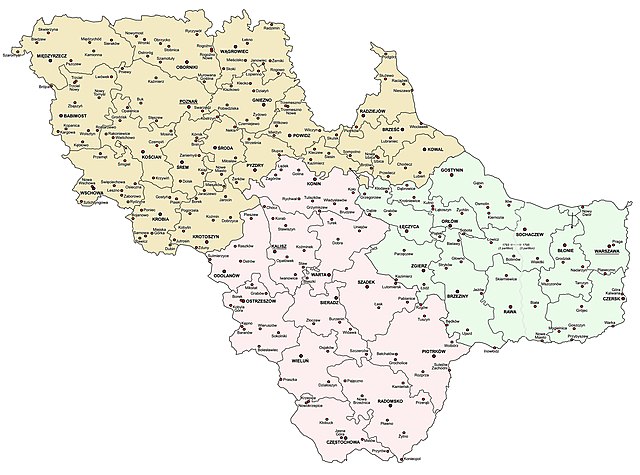
English: South Prussia (Südpreußen, Prusy Południowe) as of 1795–1806 – administrative map with departments, districts and all towns (in Polish language).
Yellow = Posen (Poznań) department; Pink = Kalisch (Kalisz) department; Green = Warschau (Warsaw) department. The boundary between 2nd and 3rd partition of Poland (1793/1795) shown in the Warsaw Department. All localtities which had town status sometime during the period 1793–1806 are shown.Polski: Prusy Południowe wg stanu z 1795–1806 – mapa administracyjna przedstawiając departamenty, powiaty and i wszystkie miasta (w języku polskim).
Kolor żółty – departament poznański; kolor różówy – departament kaliski; kolor seledynowy – departament warszawski. Granica między I a II rozbiorem Polski (1793/1795) pokazana w granicach departamentu warszawskiego. Wszystkie miejscowości posiadające prawa miejskie w latach 1793–1806 są pokzane.Deutsch: Südpreußen im 1795-1806 - Verwaltungskarte mit Kammerdepartements, Kreisen und allen Städten (in polnischer Sprache).
Gelb = Kammerdepartement Posen; Rosa = Kammerdepartement Kalisch; Grün = Kammerdepartement Warschau. Die Grenze zwischen der 2. und 3. Abteilung Polens (1793/1795) im Warschauer Kammerdepartement. Alle Ortschaften, die irgendwann im Zeitraum 1793-1806 Stadtstatus hatten, werden gezeigt.Svenska: Sydpreussen under 1795–1806 – administrativ karta över department, distrikt och alla städer på polska).
Gul färg= Posen (Poznań) departamentet; Rosa färg= Kalisch (Kalisz) departamentet; Ljusgrön färg = Warschau (Warszawa) departamentet. Gränsen mellan Polens andra och tredje delning (1793/1795) syns över Warszawa departamentet. Samtliga orter som haft stadsrättigheter någon gång under perioden 1793–1806 visa.Македонски: Јужна Прусија од 1795-1806 - административна карта со оддели, области и сите градови (на полски јазик).
Жолта боја = Познан (Позен); розова боја = Калиш (Калиш); зелена боја = Варшава (Варшава). Границата помеѓу 2 и 3 партиција (1793/1795) прикажана во Варшавскиот оддел. Сите локалитети кои имале статус на град некаде во периодот 1793-1806 година се прикажани. |
| Date | |
| Source | Own work |
| Author | Qqerim |
Licensing
- You are free:
- to share – to copy, distribute and transmit the work
- to remix – to adapt the work
- Under the following conditions:
- attribution – You must give appropriate credit, provide a link to the license, and indicate if changes were made. You may do so in any reasonable manner, but not in any way that suggests the licensor endorses you or your use.
File history
Click on a date/time to view the file as it appeared at that time.
| Date/Time | Thumbnail | Dimensions | User | Comment | |
|---|---|---|---|---|---|
| current | 01:33, 26 September 2018 | | 3,000 × 2,225 (1.38 MB) | Qqerim | minor corrections |
| 13:44, 23 September 2018 |  | 3,000 × 2,225 (1.37 MB) | Qqerim | Minor corrections | |
| 00:11, 23 September 2018 |  | 3,000 × 2,225 (1.36 MB) | Qqerim | User created page with UploadWizard |
File usage
Global file usage
The following other wikis use this file:
- Usage on de.wikipedia.org
- Usage on he.wikipedia.org
- Usage on pl.wikipedia.org
- Prusy Południowe
- Departament kaliski (Prusy Południowe)
- Wikipedysta:Qqerim/mapy
- Departament poznański (Prusy Południowe)
- Departament warszawski (Prusy Południowe)
- Szablon:Prusy Południowe
- Departament piotrkowski
- Wikipedysta:Malarz pl/szablony/Państwo infobox/7
- Wikipedysta:Malarz pl/szablony/Państwo infobox
- Usage on tr.wikipedia.org
- Usage on zh.wikipedia.org