.jpg)
.jpg&action=edit&redlink=1)

Original file (4,000 × 3,000 pixels, file size: 3.31 MB, MIME type: image/jpeg)
| This is a file from the Wikimedia Commons. Information from its description page there is shown below. Commons is a freely licensed media file repository. You can help. |
.jpg)
Summary
| Description |
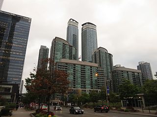
South Core is a neighbourhood located in downtown Toronto, Ontario, Canada. The remodeling and restoration of Union Station and the construction of a new wave of business and condominium towers is central to this area's forecast growth. The area has grown rapidly in the last several years. Toronto's Gardiner Expressway is currently being rebuilt to provide a new one-acre park in the area. Two ramps to the expressway at York and Bay streets are being removed to make room for the park. The South Core was once part Toronto Harbour and now lies on land fill done from the 1850s to 1920s to accommodate railway lines. In the 1950s, the Gardiner Expressway emerged to cut off much of the city from the lakefront as rings of highways were built around many North American cities as was the trend at the time. In previous decades, much of the land was unusable due to its designation as rail lands. Today, that stigma is gone as multiple business and condominium towers have risen and more continue to be built. The name South Core derives from south of the downtown (or financial) core of the city. The name of the area mimics the district names Soho in New York City and Soho in West End of London. In October 2013, Delta Hotels announced a new flagship hotel central to South Core. Maple Leaf Square, home to Air Canada Centre and thus the home of the Toronto Raptors and Toronto Maple Leafs, sometimes plays host to live broadcasts of sporting events on the huge video screen facing Bremner Boulevard. RealSports Toronto sports bar is located in Maple Leaf Square. The Telus Tower and the PricewaterhouseCoopers buildings are prominent office towers in the district. en.wikipedia.org/wiki/South_Core,_Toronto en.wikipedia.org/wiki/Wikipedia:Text_of_Creative_Commons_... |
| Date | Taken on 28 September 2015, 15:04 |
| Source | South Core, Toronto, Ontario |
| Author | Ken Lund from Reno, Nevada, USA |
| Camera location | | View this and other nearby images on: OpenStreetMap |
|---|
.jpg¶ms=043.642244_N_-079.385412_E_globe:Earth_type:camera_source:Flickr_&language=en)
Licensing
- You are free:
- to share – to copy, distribute and transmit the work
- to remix – to adapt the work
- Under the following conditions:
- attribution – You must give appropriate credit, provide a link to the license, and indicate if changes were made. You may do so in any reasonable manner, but not in any way that suggests the licensor endorses you or your use.
- share alike – If you remix, transform, or build upon the material, you must distribute your contributions under the same or compatible license as the original.
| This image was originally posted to Flickr by Ken Lund at https://flickr.com/photos/75683070@N00/21652181788. It was reviewed on 19 December 2016 by FlickreviewR and was confirmed to be licensed under the terms of the cc-by-sa-2.0. |
File history
Click on a date/time to view the file as it appeared at that time.
| Date/Time | Thumbnail | Dimensions | User | Comment | |
|---|---|---|---|---|---|
| current | 15:31, 19 December 2016 | | 4,000 × 3,000 (3.31 MB) | Mindmatrix | Transferred from Flickr via Flickr2Commons |
.jpg)