
Size of this PNG preview of this SVG file: 568 × 384 pixels. Other resolutions: 320 × 216 pixels | 640 × 433 pixels | 1,024 × 692 pixels | 1,280 × 865 pixels | 2,560 × 1,731 pixels.
Original file (SVG file, nominally 568 × 384 pixels, file size: 732 KB)
| This is a file from the Wikimedia Commons. Information from its description page there is shown below. Commons is a freely licensed media file repository. You can help. |
Summary
| Description |
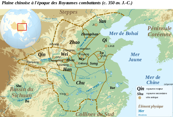
Français : Carte de la plaine Chinoise à l'époque des royaumes combattants (c. 350 av. J.C.). Le tracé des frontières est approximatif. A partir des données :
English: Map of the Chinese plain, c. 350 BC. Warring States Period |
||
| Date | |||
| Source |
This file was derived from: Chinese plain 5c. BC-fr.svg: |
||
| Author | Zunkir | ||
| SVG development |
|
Licensing
I, the copyright holder of this work, hereby publish it under the following license:
This file is licensed under the Creative Commons Attribution-Share Alike 3.0 Unported license.
- You are free:
- to share – to copy, distribute and transmit the work
- to remix – to adapt the work
- Under the following conditions:
- attribution – You must give appropriate credit, provide a link to the license, and indicate if changes were made. You may do so in any reasonable manner, but not in any way that suggests the licensor endorses you or your use.
- share alike – If you remix, transform, or build upon the material, you must distribute your contributions under the same or compatible license as the original.
Original upload log
This image is a derivative work of the following images:
- Chinese plain 5c. BC-fr.svg licensed with Cc-by-sa-3.0
Uploaded with derivativeFX
File history
Click on a date/time to view the file as it appeared at that time.
| Date/Time | Thumbnail | Dimensions | User | Comment | |
|---|---|---|---|---|---|
| current | 09:21, 16 April 2012 | | 568 × 384 (732 KB) | Zunkir | Modification des frontières à partir de P. B. Ebrey, The Cambridge Illustrated History of China, Cambridge, 1999. |
| 21:34, 2 March 2012 |  | 568 × 384 (741 KB) | Zunkir | Modifications des frontières. | |
| 21:44, 22 February 2012 |  | 568 × 384 (741 KB) | Zunkir | Modif. frontières Zhao | |
| 21:39, 22 February 2012 |  | 568 × 384 (740 KB) | Zunkir | == {{int:filedesc}} == {{Information |Description={{fr|1=Carte de la plaine Chinoise à l'époque des royaumes combattants (c. 350 av. J.C.)}}{{en|1=Map of the Chinese plain, c. 350 BC. Warring States Period}} |Source={{Derived from|Chinese_plain_5c._BC-f |
File usage
The following pages on the English Wikipedia use this file (pages on other projects are not listed):
Global file usage
The following other wikis use this file:
- Usage on fr.wikipedia.org
- Usage on lt.wikipedia.org
- Usage on pl.wikipedia.org
- Usage on uk.wikipedia.org