
Size of this preview: 543 × 599 pixels. Other resolutions: 217 × 240 pixels | 435 × 480 pixels | 936 × 1,033 pixels.
Original file (936 × 1,033 pixels, file size: 1.23 MB, MIME type: image/png)
| This is a file from the Wikimedia Commons. Information from its description page there is shown below. Commons is a freely licensed media file repository. You can help. |
Summary
| Description |
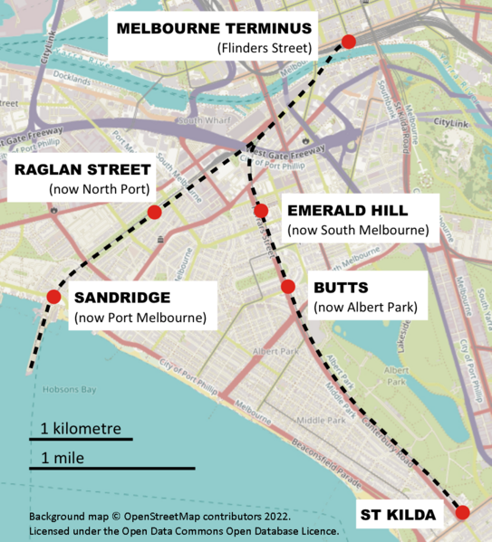
English: Route map of the former Melbourne and Hobson's Bay Railway Company lines, Victoria, Australia |
| Date | |
| Source |
Background map: OpenStreetMap (https://www.openstreetmap.org/#map=14/-37.8391/144.9525&layers=H) Overlay: SCHolar44 |
| Author | OpenStreetMap contributors and SCHolar44 |
| Camera location | | View this and other nearby images on: OpenStreetMap |
|---|
Licensing
This file is licensed under the Creative Commons Attribution-Share Alike 4.0 International license.
- You are free:
- to share – to copy, distribute and transmit the work
- to remix – to adapt the work
- Under the following conditions:
- attribution – You must give appropriate credit, provide a link to the license, and indicate if changes were made. You may do so in any reasonable manner, but not in any way that suggests the licensor endorses you or your use.
- share alike – If you remix, transform, or build upon the material, you must distribute your contributions under the same or compatible license as the original.
File history
Click on a date/time to view the file as it appeared at that time.
| Date/Time | Thumbnail | Dimensions | User | Comment | |
|---|---|---|---|---|---|
| current | 07:04, 24 May 2022 | | 936 × 1,033 (1.23 MB) | SCHolar44 | Uploaded a work by OpenStreetMap contributors and SCHolar44 from Background map: OpenStreetMap (https://www.openstreetmap.org/#map=14/-37.8391/144.9525&layers=H) Overlay: SCHolar44 with UploadWizard |
File usage
The following pages on the English Wikipedia use this file (pages on other projects are not listed):