
Size of this preview: 800 × 533 pixels. Other resolutions: 320 × 213 pixels | 640 × 427 pixels | 1,024 × 683 pixels | 1,280 × 853 pixels | 3,000 × 2,000 pixels.
Original file (3,000 × 2,000 pixels, file size: 3.25 MB, MIME type: image/jpeg)
| This is a file from the Wikimedia Commons. Information from its description page there is shown below. Commons is a freely licensed media file repository. You can help. |
Summary
| Description |
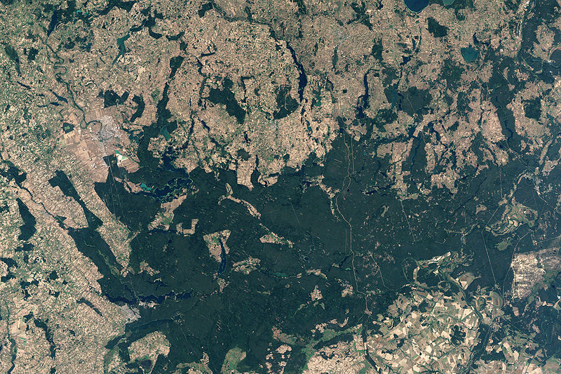
English: NASA’s Landsat 7 satellite captured this image of Rospuda Valley. This true-color image shows a patchwork of peat bog and agricultural fields. In contrast to the nearly uniform deep-green wetlands, the fields appear as close-knit rectangles of varied shades of green and beige. Rospuda River meanders between cultivated fields in the northwest and wetland territory in the southeast, connecting with Lake Necko. Numerous other lakes and ponds appear north and east of Lake Necko, some of them overlapping agricultural areas. |
| Date | |
| Source | NASA Earth Observatory |
| Author | Jesse Allen |
NASA image created by Jesse Allen, using Landsat data provided by the United States Geological Survey.
Licensing
| This file is in the public domain in the United States because it was solely created by NASA. NASA copyright policy states that "NASA material is not protected by copyright unless noted". (See Template:PD-USGov, NASA copyright policy page or JPL Image Use Policy.) | ||
 |
Warnings:
|
File history
Click on a date/time to view the file as it appeared at that time.
| Date/Time | Thumbnail | Dimensions | User | Comment | |
|---|---|---|---|---|---|
| current | 13:34, 19 April 2009 | | 3,000 × 2,000 (3.25 MB) | Originalwana | {{Information |Description={{en|1=NASA’s Landsat 7 satellite captured this image of Rospuda Valley. This true-color image shows a patchwork of peat bog and agricultural fields. In contrast to the nearly uniform deep-green wetlands, the fields appear as |
File usage
The following pages on the English Wikipedia use this file (pages on other projects are not listed):
Global file usage
The following other wikis use this file:
- Usage on ka.wikipedia.org
- Usage on lt.wikipedia.org
- Usage on ru.wikipedia.org
- Usage on uk.wikipedia.org
- Usage on zh.wikipedia.org