No higher resolution available.
Rockmount,_Church_Road_-_geograph.org.uk_-_1770732.jpg (640 × 516 pixels, file size: 173 KB, MIME type: image/jpeg)
| This is a file from the Wikimedia Commons. Information from its description page there is shown below. Commons is a freely licensed media file repository. You can help. |
Summary
| Description |
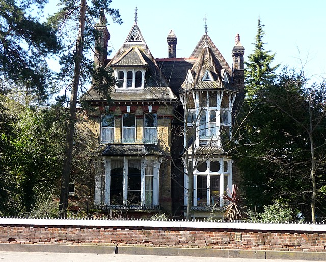
English: Rockmount, Church Road Probably the best of the suburban villas on Church Road, this splendidly spiky Victorian affair dates from 1873 and was designed by the splendidly-named Sextus Dyball. It is crammed with detail, in particular the bay on the right which has brick nogging and two demi-octagonal roofs. Grade II listed.
Dyball was a speculative builder-architect who designed a number of buildings in the area. Jonathan Meades wrote of him that he was "a local builder to whom all devotees of inspired ugliness and sinister gracelessness will be forever indebted. Did Dyball know what he was doing? Did he have any idea of the sensations that his creations would provoke? It is improbable that he was out to shock. Rather, it seems that he ... subscribed to an aesthetic system that, although not far from us, feels chronologically, seems unfathomably distant a vestige of an alien civilisation." |
| Date | |
| Source | From geograph.org.uk |
| Author | Stephen Richards |
| Attribution (required by the license) | Stephen Richards / Rockmount, Church Road / |
| Camera location | | View this and other nearby images on: OpenStreetMap |
|---|
_heading:292.00&language=en)
| Object location | | View this and other nearby images on: OpenStreetMap |
|---|
_heading:292.00&language=en)
Licensing

|
This image was taken from the Geograph project collection. See this photograph's page on the Geograph website for the photographer's contact details. The copyright on this image is owned by Stephen Richards and is licensed for reuse under the Creative Commons Attribution-ShareAlike 2.0 license.
|
This file is licensed under the Creative Commons Attribution-Share Alike 2.0 Generic license.
Attribution: Stephen Richards
- You are free:
- to share – to copy, distribute and transmit the work
- to remix – to adapt the work
- Under the following conditions:
- attribution – You must give appropriate credit, provide a link to the license, and indicate if changes were made. You may do so in any reasonable manner, but not in any way that suggests the licensor endorses you or your use.
- share alike – If you remix, transform, or build upon the material, you must distribute your contributions under the same or compatible license as the original.
File history
Click on a date/time to view the file as it appeared at that time.
| Date/Time | Thumbnail | Dimensions | User | Comment | |
|---|---|---|---|---|---|
| current | 13:25, 14 March 2011 | | 640 × 516 (173 KB) | GeographBot | == {{int:filedesc}} == {{Information |description={{en|1=Rockmount, Church Road Probably the best of the suburban villas on Church Road, this splendidly spiky Victorian affair dates from 1873 and was designed by the splendidly-named Sextus Dyball. It is c |
File usage
The following pages on the English Wikipedia use this file (pages on other projects are not listed):
Global file usage
The following other wikis use this file:
- Usage on it.wikipedia.org
- Usage on www.wikidata.org