
Size of this preview: 600 × 600 pixels. Other resolutions: 240 × 240 pixels | 480 × 480 pixels | 768 × 768 pixels | 1,024 × 1,024 pixels | 2,048 × 2,048 pixels | 3,714 × 3,714 pixels.
Original file (3,714 × 3,714 pixels, file size: 5.78 MB, MIME type: image/jpeg)
| This is a file from the Wikimedia Commons. Information from its description page there is shown below. Commons is a freely licensed media file repository. You can help. |
Summary
| Description |
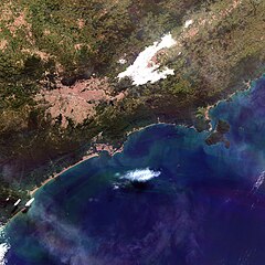
Português: Região Metropolitana de São Paulo e RMVale, terça passada. Áreas urbanas em salpicado avermelhado. Grande São Paulo desde Barueri na esq. da imagem. Logo acima Jundiaí e no alto à esquerda Itatiba, e um pouco à sua dir. Bragança Paulista. Florestas em verde escuro e agricultura em verde claro. Nuvens baixas, em branco, cobrem Jacareí e parte de São José dos Campos. No alto à dir., Pindamonhangaba. O litoral aparece desde Itanhaém, embaixo à esq., até a Praia do Sapê em Ubatuba. No oceano, águas claras em azul, eutrofizadas e com sedimentos em suspensão em tons de verde e esbranquiçados / São Paulo City and Paraíba do Sul River Valley Metropolitan Regions. Urban areas in redish saltpepper. São Paulo Metro appears, on image left, starting from Barueri. Above it is Jundiaí and at image left top, Itatiba, with Bragança Paulista to its right. Forest in dark green and agriculture in light green. Jacareí and part of São José dos Campos are covered by low clouds in white. At image right top is Pindamonhangaba. Coast appears from Itanhaém, at left bottom.
Imagem / Image CBERS4 AWFI Região Metropolitana de São Paulo e do Vale do Paraíba. Coordenadas do centro da imagem / Image center: 23°30'32.0"S 46°04'10.2"W Data / Date: 28-05-2019 / 2019-28-05 RGB 151413 (cor verdadeira / true color) Cena / Scene: 151 / 129 Autor / Author: Oton Barros (DSR/OBT/INPE) Imagem em HD / HD Image Visite-nos / Visit us: www.dsr.inpe.br |
| Date | |
| Source | https://www.flickr.com/photos/153282474@N02/48013448306/ |
| Author | Coordenação-Geral de Observação da Terra/INPE |
| Other versions |

Licensing
This file is licensed under the Creative Commons Attribution-Share Alike 2.0 Generic license.
- You are free:
- to share – to copy, distribute and transmit the work
- to remix – to adapt the work
- Under the following conditions:
- attribution – You must give appropriate credit, provide a link to the license, and indicate if changes were made. You may do so in any reasonable manner, but not in any way that suggests the licensor endorses you or your use.
- share alike – If you remix, transform, or build upon the material, you must distribute your contributions under the same or compatible license as the original.
| This image was originally posted to Flickr by Coordenação-Geral de Observação da Terra/INPE at https://flickr.com/photos/153282474@N02/48013448306. It was reviewed on 9 April 2020 by FlickreviewR 2 and was confirmed to be licensed under the terms of the cc-by-sa-2.0. |
File history
Click on a date/time to view the file as it appeared at that time.
| Date/Time | Thumbnail | Dimensions | User | Comment | |
|---|---|---|---|---|---|
| current | 10:13, 9 April 2020 | | 3,714 × 3,714 (5.78 MB) | Jo-Jo Eumerus | Uploaded a work by Coordenação-Geral de Observação da Terra/INPE from https://www.flickr.com/photos/153282474@N02/48013448306/ with UploadWizard |
File usage
No pages on the English Wikipedia use this file (pages on other projects are not listed).