
Size of this PNG preview of this SVG file: 690 × 228 pixels. Other resolutions: 320 × 106 pixels | 640 × 211 pixels | 1,024 × 338 pixels | 1,280 × 423 pixels | 2,560 × 846 pixels.
Original file (SVG file, nominally 690 × 228 pixels, file size: 51 KB)
| This is a file from the Wikimedia Commons. Information from its description page there is shown below. Commons is a freely licensed media file repository. You can help. |
Summary
| Description |
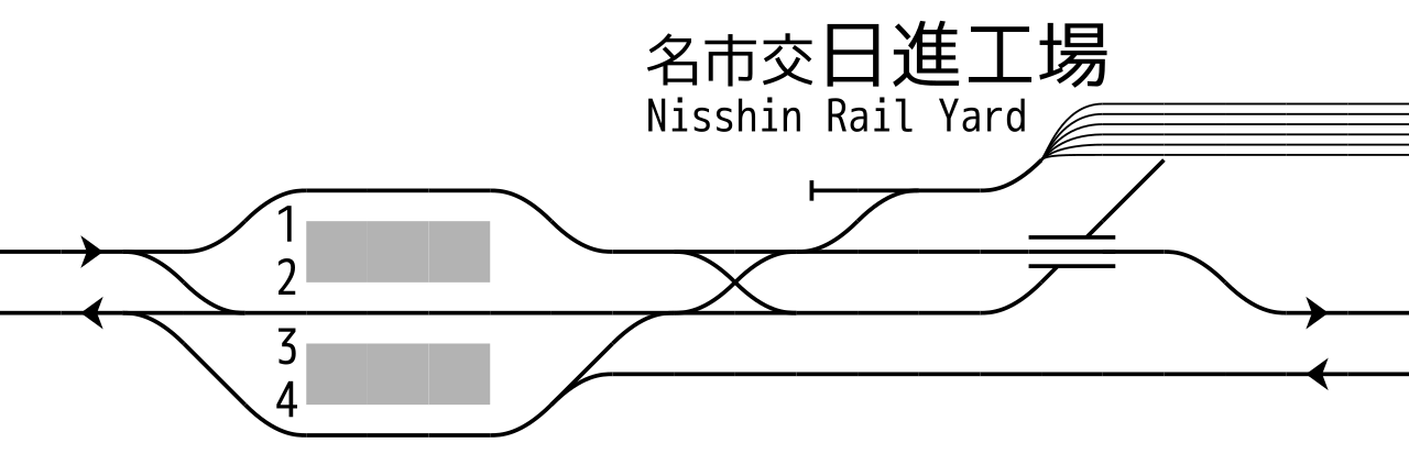
English: Rail tracks map of Nagoya Railroad Toyota Line and Nagoya Municipal Subway Tsurumai Line Akaike Station. Reference material: DENKISHA KENKYUKAI, "THE RAILWAY PICTORIAL" Vol.816, Extra edition - "名古屋鉄道(Nagoya Railroad)" insert page at end, 2009-03. Created from icons in Category:Rail_tracks_map_template 日本語: 名鉄豊田線・名市交鶴舞線 赤池駅 配線図 参考文献:巻末折込「名古屋鉄道 配線略図」(『鉄道ピクトリアル No.816 2009年3月号臨時増刊』電気車研究会、2009年) 凡例は駅配線図テンプレートを参照 |
| Date | |
| Source | Own work |
| Author | ButuCC |
Licensing
I, the copyright holder of this work, hereby publish it under the following license:
This file is licensed under the Creative Commons Attribution-Share Alike 3.0 Unported license.
- You are free:
- to share – to copy, distribute and transmit the work
- to remix – to adapt the work
- Under the following conditions:
- attribution – You must give appropriate credit, provide a link to the license, and indicate if changes were made. You may do so in any reasonable manner, but not in any way that suggests the licensor endorses you or your use.
- share alike – If you remix, transform, or build upon the material, you must distribute your contributions under the same or compatible license as the original.
File history
Click on a date/time to view the file as it appeared at that time.
| Date/Time | Thumbnail | Dimensions | User | Comment | |
|---|---|---|---|---|---|
| current | 06:23, 3 December 2017 | 690 × 228 (51 KB) | ButuCC | modify | |
| 17:34, 10 October 2013 | 692 × 271 (40 KB) | ButuCC | User created page with UploadWizard |
File usage
The following pages on the English Wikipedia use this file (pages on other projects are not listed):
Global file usage
The following other wikis use this file:
- Usage on de.wikipedia.org
- Usage on ja.wikipedia.org
- Usage on zh.wikipedia.org