File:Quisling Towers Apartments, Gilman Street and Wisconsin Avenue, Mansion Hill, Madison, WI - 52763166559.jpg

Original file (2,813 × 3,751 pixels, file size: 4 MB, MIME type: image/jpeg)
| This is a file from the Wikimedia Commons. Information from its description page there is shown below. Commons is a freely licensed media file repository. You can help. |
Summary
| Description |
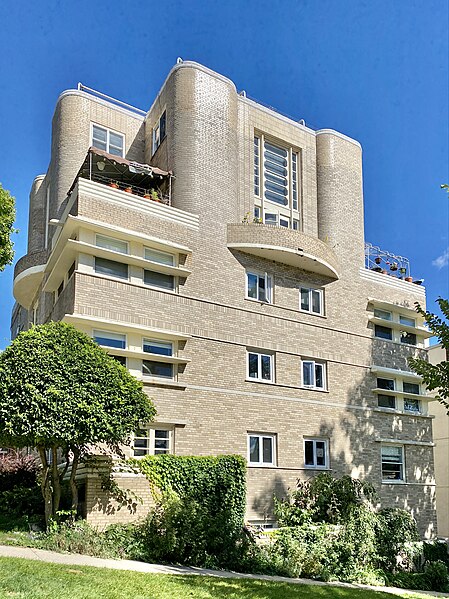
English: Built in 1937, this Streamline Moderne or Art Moderne-style building was designed by Lawrence Monberg for Dr. Abraham Quisling, and is known as Quisling Towers. The building is one of three notable Art Moderne-style buildings designed by Monberg for the Quisling family, whom were prominent physicians of Norwegian descent in Madison during the mid-20th Century. The building originally housed twenty-six apartment units, and despite a few systems and features being modernized, the building retains most of its historic character-defining elements. The building was built of fire resistant hollow clay tile, a common building material at the time, with plaster on the interior and buff brick cladding with terra cotta and bedford limestone trim on the exterior obscuring the structural material. The building sits on a sloped site, being six stories in height in the rear, along a private drive off of Wisconsin Avenue, and five stories in the front, along Gilman Street.
The building features a buff brick exterior with corner bands of windows featuring horizontal fins that create strong visual horizontal emphasis at the building’s corners, with casement, one-over-one double-hung, and fixed windows being present on various parts of the building. The building’s front entrance is along Gilman Avenue, flanked by low stone walls and featuring a suspended semi-circular aluminum canopy above, with semi-circular door handles and sidelights. The building’s facade is broken by thin belt coursing at the top and bottom of the windows on most of the floors, which features soldier brick courses between the second and third floors. At the base of the building and at the terraces, there are thick bands of trim with flutes that are aligned horizontally, further de-emphasizing the building’s verticality, with a stepped retaining wall at the basement light well along Wisconsin Avenue also featuring the same trim cap. On the fifth floor, the building has corner setbacks, which are home to rooftop terraces, two-story “tower” sections with curved brick piers flanking curved brick balconies with large fixed storefronts and french doors at the balconies, and stacked bond and soldier brick framing the storefronts. The fifth floor is the smallest, consisting of the “tower” with the curved brick piers and balconies on the floor below, as well as a setback section to the northeast, with two large roof terraces on the rooftop of the building’s fourth floor at the northeast end of the building. The rooftop terrace is enclosed by a modern wire safety railing, and features curved corners, following the curved corners of the fourth floor below. The rear of the building features recessed balconies enclosed by low brick walls on the exterior, which have had their views of the State Capitol blocked by an adjacent building constructed several decades later. The building’s interior features plaster walls with a lobby featuring curved walls and a linoleum floor, recessed radiators, simple stone fireplace surrounds, curved staircases with metal handrails, art deco-style pendant and sconce light fixtures, and kitchens with the original cabinets, subway tile wall cladding, built-in cutting boards, and tile countertops. The building was listed on the National Register of Historic Places in 1984, owing to its architectural significance. The building today is one of the most distinctive buildings on the Downtown Madison isthmus, and is an excellent example of Art Moderne architecture, and is the best preserved of the three significant Monberg-designed buildings from the time period in the Mansion Hill district. The building remains in use as a rental apartment building. |
| Date | |
| Source | https://www.flickr.com/photos/59081381@N03/52763166559/ |
| Author | w_lemay |
| Camera location | | View this and other nearby images on: OpenStreetMap |
|---|
Licensing
- You are free:
- to share – to copy, distribute and transmit the work
- to remix – to adapt the work
- Under the following conditions:
- attribution – You must give appropriate credit, provide a link to the license, and indicate if changes were made. You may do so in any reasonable manner, but not in any way that suggests the licensor endorses you or your use.
- share alike – If you remix, transform, or build upon the material, you must distribute your contributions under the same or compatible license as the original.
| This image was originally posted to Flickr by w_lemay at https://flickr.com/photos/59081381@N03/52763166559. It was reviewed on 22 March 2023 by FlickreviewR 2 and was confirmed to be licensed under the terms of the cc-by-sa-2.0. |
File history
Click on a date/time to view the file as it appeared at that time.
| Date/Time | Thumbnail | Dimensions | User | Comment | |
|---|---|---|---|---|---|
| current | 18:30, 22 March 2023 | | 2,813 × 3,751 (4 MB) | Ser Amantio di Nicolao | Uploaded a work by w_lemay from https://www.flickr.com/photos/59081381@N03/52763166559/ with UploadWizard |