
Size of this preview: 800 × 577 pixels. Other resolutions: 320 × 231 pixels | 640 × 461 pixels | 1,024 × 738 pixels | 1,280 × 923 pixels | 2,560 × 1,845 pixels | 5,182 × 3,735 pixels.
Original file (5,182 × 3,735 pixels, file size: 12.61 MB, MIME type: image/jpeg)
| This is a file from the Wikimedia Commons. Information from its description page there is shown below. Commons is a freely licensed media file repository. You can help. |
Summary
| Description |
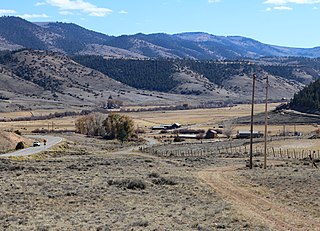
English: A view of Powderhorn, Colorado and the Powderhorn Valley, in Gunnison County, Colorado. The highway on the left is Colorado State Highway 149. |
| Date | |
| Source | Own work |
| Author | Jeffrey Beall |
| Camera location | | View this and other nearby images on: OpenStreetMap |
|---|
Licensing
I, the copyright holder of this work, hereby publish it under the following license:
This file is licensed under the Creative Commons Attribution 4.0 International license.
- You are free:
- to share – to copy, distribute and transmit the work
- to remix – to adapt the work
- Under the following conditions:
- attribution – You must give appropriate credit, provide a link to the license, and indicate if changes were made. You may do so in any reasonable manner, but not in any way that suggests the licensor endorses you or your use.
File history
Click on a date/time to view the file as it appeared at that time.
| Date/Time | Thumbnail | Dimensions | User | Comment | |
|---|---|---|---|---|---|
| current | 21:28, 24 October 2018 | | 5,182 × 3,735 (12.61 MB) | Jeffrey Beall | {{Information |description ={{en|1=A view of {{W|Powderhorn, Colorado}} and the Powderhorn Valley, in {{W|Gunnison County, Colorado}}. The highway on the left is {{W|Colorado State Highway 149}}.}} |date =2018-10-21 |source ={{own}} |author =Jeffrey Beall }} {{Location|38|17|3.09|N|107|7|32.46|W}} Category:Powderhorn, Colorado Category:October 2018 in Colorado |
File usage
The following pages on the English Wikipedia use this file (pages on other projects are not listed):
Global file usage
The following other wikis use this file:
- Usage on azb.wikipedia.org
- Usage on fa.wikipedia.org
- Usage on nv.wikipedia.org
- Usage on www.wikidata.org
- Usage on zh.wikipedia.org