
Size of this preview: 800 × 287 pixels. Other resolutions: 320 × 115 pixels | 640 × 229 pixels | 1,862 × 667 pixels.
Original file (1,862 × 667 pixels, file size: 231 KB, MIME type: image/jpeg)
| This is a file from the Wikimedia Commons. Information from its description page there is shown below. Commons is a freely licensed media file repository. You can help. |
Summary
| Description |
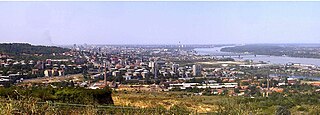
Srpskohrvatski / српскохрватски: Panorama Karaburme (u sredini slike). Na levom kraju se vidi Zvezdara, na desnom je Dunav i, odeljen Adom Hujom, Rukavac (manja vodena površina južno tj. ispod). Južno (dole i levo) od Rukavca je kraj Rospi Ćuprija. Dva visoka dimnjaka ispred naselja pripadaju ciglanama (verovatno "Polet" i "Jedinstvo"), koje će verovatno nestati, jer je planirana gradnja naselja Višnjičko Polje na padini ispod mesta snimanja. Dunav premošćuje Pančevački most. U daljini se nazire grad, sve do Novog Beograda i Zemuna; na horizontu se ističu Beograđanka, Zapadna kapija Beograda (levo, preko Zvezdare) i dimnjak električne centrale na Dorćolu (blizu Dunava). Snimljeno 7.8.2008. sa brda (i groblja) Lešće, generalno u pravcu zapada. |
| Date | 24 January 2009 (original upload date) |
| Source | Transferred from sh.wikipedia; transferred to Commons by User:BokicaK using CommonsHelper. |
| Author | Original uploader was Alekol at sh.wikipedia |
| Permission (Reusing this file) |
Released under the GNU Free Documentation License. |
Licensing

|
Permission is granted to copy, distribute and/or modify this document under the terms of the GNU Free Documentation License, Version 1.2 or any later version published by the Free Software Foundation; with no Invariant Sections, no Front-Cover Texts, and no Back-Cover Texts. A copy of the license is included in the section entitled GNU Free Documentation License. |
| This file is licensed under the Creative Commons Attribution-Share Alike 3.0 Unported license. | ||
| Attribution: Wikipedia user Alekol | ||
| ||
| This licensing tag was added to this file as part of the GFDL licensing update. |
Original upload log
The original description page was here. All following user names refer to sh.wikipedia.
- 2009-01-24 19:56 Alekol 1862×667× (236285 bytes) Panorama [[Karaburma|Karaburme]] (u sredini slike). Na levom kraju se vidi [[Zvezdara]], na desnom je [[Dunav]] i, odeljen [[Ada Huja|Adom Hujom]], Rukavac (manja vodena površina južno tj. ispod). Južno (dole i levo) od Rukavca je kraj [[Rospi Ćuprija
File history
Click on a date/time to view the file as it appeared at that time.
| Date/Time | Thumbnail | Dimensions | User | Comment | |
|---|---|---|---|---|---|
| current | 09:20, 8 September 2009 | 1,862 × 667 (231 KB) | File Upload Bot (Magnus Manske) | {{BotMoveToCommons|sh.wikipedia|year={{subst:CURRENTYEAR}}|month={{subst:CURRENTMONTHNAME}}|day={{subst:CURRENTDAY}}}} {{Information |Description={{sh|Panorama Karaburme (u sredini slike). Na levom kraju se vidi sh:Zvezdara, na de |
File usage
The following pages on the English Wikipedia use this file (pages on other projects are not listed):
Global file usage
The following other wikis use this file:
- Usage on el.wikipedia.org
- Usage on fr.wikipedia.org
- Usage on sh.wikipedia.org
- Usage on sr.wikipedia.org