.jpg)
.jpg&action=edit&redlink=1)

Original file (3,408 × 5,086 pixels, file size: 6.2 MB, MIME type: image/jpeg)
| This is a file from the Wikimedia Commons. Information from its description page there is shown below. Commons is a freely licensed media file repository. You can help. |
.jpg)
Summary
| Description |
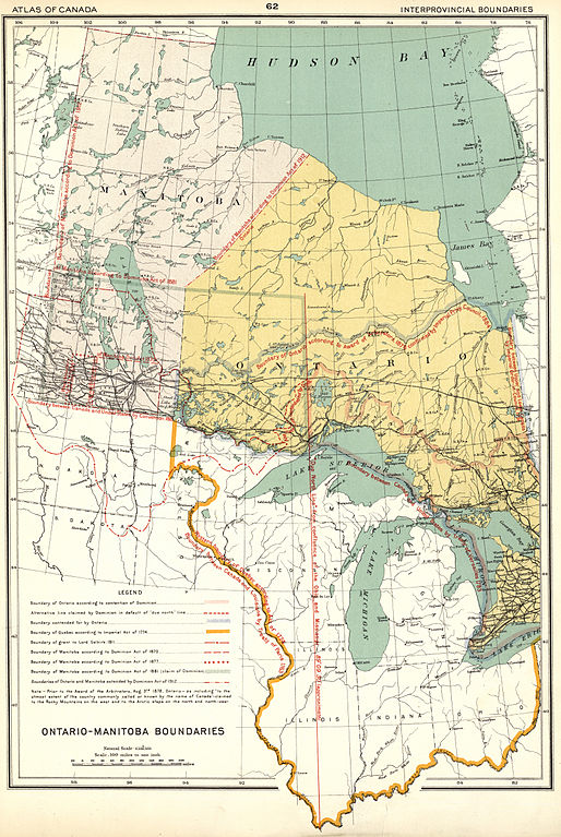
Chalifour, J. E. Ontario Manitoba Boundaries [map]. 1:6,336,000. In: Dept. of the Interior. Atlas of Canada Revised and Enlarged Edition. [Ottawa]: Dept. of the Interior, 1915, p.62. This map shows the complicated stages through which the boundaries of Manitoba evolved. The Earl of Selkirk’s grant is shown, and the boundaries of Manitoba as they were when the Province was created in 1870. The boundary revisions of 1877 indicated on this map are incorrect, because the boundary was only shifted a few miles from the astronomical line to the nearest section survey line, so that the land area did in fact not change significantly. In 1881 Manitoba was enlarged to include the area occupied by immigrant farmers to that date. Basing its case on territorial arrangements made in various early treaties between England and France and at a later time in specific Imperial Acts, the Dominion government in 1881 also attempted to extend the Manitoba boundary eastward to Lake Superior, over the rival claims and protests of Ontario. Ontario won the ensuing dispute and Manitoba had to wait until 1912 to grow in size. Its boundaries were finally extended in that year, but this time northwards to the Bay, into territory where there were no strong counter claims from neighbouring provinces. Ontario Manitoba Boundaries (1915) (Warkentin and Ruggles. Historical Atlas of Manitoba. map 63, p. 164) Map shows the following boundaries: Boundary of Quebec according to Imperial Act of 1774 Boundary of Grant to Lord Selkirk 1811 Boundary of Manitoba according to Dominion Act of 1870 Boundary of Manitoba according to Dominion Act of 1877 Boundary of Manitoba according to Dominion Act of 1881 (claim of Dominion) Boundaries of Ontario and Manitoba extended by Dominion Act of 1912 |
| Date | |
| Source | Ontario Manitoba Boundaries (1915) |
| Author | Wyman Laliberte from Edmonton, Canada |
Licensing
- You are free:
- to share – to copy, distribute and transmit the work
- to remix – to adapt the work
- Under the following conditions:
- attribution – You must give appropriate credit, provide a link to the license, and indicate if changes were made. You may do so in any reasonable manner, but not in any way that suggests the licensor endorses you or your use.
| This image was originally posted to Flickr by Manitoba Historical Maps at https://www.flickr.com/photos/11496488@N07/2104873457. It was reviewed on 9 March 2014 by FlickreviewR and was confirmed to be licensed under the terms of the cc-by-2.0. |
File history
Click on a date/time to view the file as it appeared at that time.
| Date/Time | Thumbnail | Dimensions | User | Comment | |
|---|---|---|---|---|---|
| current | 21:41, 9 March 2014 | | 3,408 × 5,086 (6.2 MB) | Geo Swan | {{Information |Description=Chalifour, J. E. Ontario Manitoba Boundaries [map]. 1:6,336,000. In: Dept. of the Interior. Atlas of Canada Revised and Enlarged Edition. [Ottawa]: Dept. of the Interior, 1915, p.62. This map shows the complicated stages th... |
.jpg)