
Size of this preview: 285 × 599 pixels. Other resolutions: 114 × 240 pixels | 554 × 1,164 pixels.
Original file (554 × 1,164 pixels, file size: 142 KB, MIME type: image/png)
| This is a file from the Wikimedia Commons. Information from its description page there is shown below. Commons is a freely licensed media file repository. You can help. |
Summary
| Description |
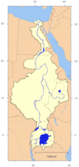
English: Course and Watershed of the Nile with political boundaries.
Deutsch: Verlauf und Einzugsgebiet des Nils mit Staatsgrenzen. |
| Date | |
| Source | The map has been created with the Generic Mapping Tools: http://gmt.soest.hawaii.edu/ using additional public comain data from the VMAP0 and HYDRO1K data sets. The map is in Transverse Mercator projection with central meridian at 32.5° east. Note that the south-western border of Sudan is the watershed. |
| Author | Imagico |
| Permission (Reusing this file) |
This file is licensed under the Creative Commons Attribution-Share Alike 2.5 Generic license.
|
| Other versions | Image:Nile_watershed_topo.png |
Licensing
I, the copyright holder of this work, hereby publish it under the following license:
This file is licensed under the Creative Commons Attribution-Share Alike 2.5 Generic license.
- You are free:
- to share – to copy, distribute and transmit the work
- to remix – to adapt the work
- Under the following conditions:
- attribution – You must give appropriate credit, provide a link to the license, and indicate if changes were made. You may do so in any reasonable manner, but not in any way that suggests the licensor endorses you or your use.
- share alike – If you remix, transform, or build upon the material, you must distribute your contributions under the same or compatible license as the original.
File history
Click on a date/time to view the file as it appeared at that time.
| Date/Time | Thumbnail | Dimensions | User | Comment | |
|---|---|---|---|---|---|
| current | 13:58, 4 January 2007 | | 554 × 1,164 (142 KB) | Imagico | == Summary == {{Information |Description= {{en|Course and Watershed of the Nile with political boundaries.}} {{de|Verlauf und Einzugsgebiet des Nils mit Staatsgrenzen.}} |Source=The map has been created with the [[:en:Generic Mapping Tools|Generic Mapping |
File usage
The following pages on the English Wikipedia use this file (pages on other projects are not listed):
Global file usage
The following other wikis use this file:
- Usage on fr.wikipedia.org
- Usage on tr.wikipedia.org