No higher resolution available.
Neutral_Buoyancy_Space_Simulator.jpg (345 × 292 pixels, file size: 17 KB, MIME type: image/jpeg)
| This is a file from the Wikimedia Commons. Information from its description page there is shown below. Commons is a freely licensed media file repository. You can help. |
|
This is an image of a place or building that is listed on the National Register of Historic Places in the United States of America. Its reference number is 85002807. |
| Camera location | | View this and other nearby images on: OpenStreetMap |
|---|
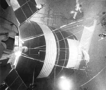
| Description | Rigging of the protective shields for Skylab was rehearsed many times in the neutral buoyancy simulator. Here, a shield made of netting (for simulation only) is being rigged underwater to determine the problems that would be encountered in space. | |||||
| Date | Uploaded on 2 August 2007 | |||||
| Source | ||||||
| Author | NASA | |||||
| Permission (Reusing this file) |
|

File history
Click on a date/time to view the file as it appeared at that time.
| Date/Time | Thumbnail | Dimensions | User | Comment | |
|---|---|---|---|---|---|
| current | 17:19, 2 August 2007 | | 345 × 292 (17 KB) | Daniel Case | Found at [http://history.nasa.gov/SP-400/ch3.htm] Category:Space exploration Category:National Historic Landmarks |
File usage
The following pages on the English Wikipedia use this file (pages on other projects are not listed):
Global file usage
The following other wikis use this file:
- Usage on de.wikipedia.org
- Usage on fr.wikipedia.org
- Usage on uk.wikipedia.org