.jpg)
.jpg&action=edit&redlink=1)

Original file (3,032 × 2,004 pixels, file size: 1.69 MB, MIME type: image/jpeg)
| This is a file from the Wikimedia Commons. Information from its description page there is shown below. Commons is a freely licensed media file repository. You can help. |
.jpg)
Summary
| Description |
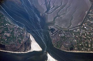
Den Helder, Netherlands is featured in this image photographed by an Expedition 15 crewmember on the International Space Station. The city and harbor of Den Helder in the northern Netherlands has been the home port of the Dutch Royal Navy for over 175 years. Its favorable location provides access to the North Sea, and has made it an important commercial shipping port in addition to its strategic role. Bright red agricultural fields to the south of Den Helder indicate another noteworthy aspect of the region--commercial farming of tulips and hyacinth. This image is an oblique view--the camera is oriented at an angle relative to "straight down"--of the Den Helder region taken from the space station, which was located to the southeast, near Dulmen, Germany (approximately 225 kilometers away in terms of ground distance) when the image was acquired. In addition to the manmade structures of the Den Helder urban area (reddish gray to gray street grids) and dockyards to the east of the city, several striking geomorphic features are visible. The extensive gray mudflats, with their prominent branching pattern (top right), indicate that this image was acquired at low tide, and suggest the general low elevation of the region. Parallel wave patterns along the mudflats and in the Marsdiep strait are formed as water interacts with the sea bottom between Den Helder and Texel Island during tidal flow. Some ship wakes are also visible. According to scientists, the bright white-gray triangular region at the southern tip of Texel Island (bottom center) is a dune field, consisting mainly of eolian (windborne) sands deposited during the last ice age. Subsequent sea level rise and shoreline processes have mobilized and re-deposited these sands into their current configuration -- including a new dune field island to the southwest of Texel (bottom center). Credit: NASA/ISS NASA Goddard Space Flight Center enables NASA’s mission through four scientific endeavors: Earth Science, Heliophysics, Solar System Exploration, and Astrophysics. Goddard plays a leading role in NASA’s accomplishments by contributing compelling scientific knowledge to advance the Agency’s mission. Follow us on Twitter Like us on Facebook Find us on Instagram |
| Date | |
| Source | Netherlands |
| Author | NASA Goddard Space Flight Center from Greenbelt, MD, USA |
Licensing
- You are free:
- to share – to copy, distribute and transmit the work
- to remix – to adapt the work
- Under the following conditions:
- attribution – You must give appropriate credit, provide a link to the license, and indicate if changes were made. You may do so in any reasonable manner, but not in any way that suggests the licensor endorses you or your use.
| This image was originally posted to Flickr by NASA Goddard Photo and Video at https://flickr.com/photos/24662369@N07/14377592196. It was reviewed on 17 September 2016 by FlickreviewR and was confirmed to be licensed under the terms of the cc-by-2.0. |
| This file is in the public domain in the United States because it was solely created by NASA. NASA copyright policy states that "NASA material is not protected by copyright unless noted". (See Template:PD-USGov, NASA copyright policy page or JPL Image Use Policy.) | ||
 |
Warnings:
|
File history
Click on a date/time to view the file as it appeared at that time.
| Date/Time | Thumbnail | Dimensions | User | Comment | |
|---|---|---|---|---|---|
| current | 20:33, 17 September 2016 | | 3,032 × 2,004 (1.69 MB) | Vanished Account Byeznhpyxeuztibuo | Transferred from Flickr via Flickr2Commons |
.jpg)