
Size of this preview: 800 × 440 pixels. Other resolutions: 320 × 176 pixels | 640 × 352 pixels | 1,024 × 563 pixels | 1,280 × 704 pixels | 3,322 × 1,828 pixels.
Original file (3,322 × 1,828 pixels, file size: 401 KB, MIME type: image/png)
| This is a file from the Wikimedia Commons. Information from its description page there is shown below. Commons is a freely licensed media file repository. You can help. |
Summary
| Description |
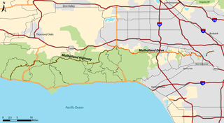
English: Road map of Mulholland Drive (eastern) and Mulholland Highway (western) in Los Angeles County, California.
|
| Date | 6 January 2006 (original upload date) |
| Source | No machine-readable source provided. Own work assumed (based on copyright claims). |
| Author | No machine-readable author provided. Darkcore~commonswiki assumed (based on copyright claims). |
Licensing
I, the copyright holder of this work, hereby publish it under the following licenses:

|
Permission is granted to copy, distribute and/or modify this document under the terms of the GNU Free Documentation License, Version 1.2 or any later version published by the Free Software Foundation; with no Invariant Sections, no Front-Cover Texts, and no Back-Cover Texts. A copy of the license is included in the section entitled GNU Free Documentation License. |
| This file is licensed under the Creative Commons Attribution-Share Alike 3.0 Unported license. | ||
| ||
| This licensing tag was added to this file as part of the GFDL licensing update. |
This file is licensed under the Creative Commons Attribution 2.5 Generic license.
- You are free:
- to share – to copy, distribute and transmit the work
- to remix – to adapt the work
- Under the following conditions:
- attribution – You must give appropriate credit, provide a link to the license, and indicate if changes were made. You may do so in any reasonable manner, but not in any way that suggests the licensor endorses you or your use.
You may select the license of your choice.
Original upload log
The original description page was here. All following user names refer to en.wikipedia.
- 2006-02-26 01:53 Darkcore 3322×1828× (410753 bytes)
- 2006-02-23 04:17 Darkcore 797×439× (112034 bytes) revised version (version is here)
- 2006-01-06 08:02 Darkcore 1653×906× (283606 bytes) (version is here)
- 2006-01-06 07:55 Darkcore 1827×1006× (292801 bytes) Map of Mulholland Drive and Mulholland Highway in Los Angeles County, California. Created by [[User:Darkcore]] using TIGER/LINE 2000 files for Los Angeles and Ventura Counties, and StreetMap USA. (version is here)
File history
Click on a date/time to view the file as it appeared at that time.
| Date/Time | Thumbnail | Dimensions | User | Comment | |
|---|---|---|---|---|---|
| current | 02:13, 17 September 2012 | | 3,322 × 1,828 (401 KB) | OgreBot | (BOT): Uploading old version of file from en.wikipedia; originally uploaded on 2006-02-26 01:53:50 by Darkcore |
| 02:13, 17 September 2012 |  | 797 × 439 (109 KB) | OgreBot | (BOT): Uploading old version of file from en.wikipedia; originally uploaded on 2006-02-23 04:17:49 by Darkcore | |
| 02:13, 17 September 2012 |  | 1,827 × 1,006 (286 KB) | OgreBot | (BOT): Uploading old version of file from en.wikipedia; originally uploaded on 2006-01-06 07:55:44 by Darkcore | |
| 12:08, 6 January 2006 |  | 1,653 × 906 (277 KB) | Darkcore~commonswiki | Map of Mulholland Drive and Mulholland Highway in Los Angeles County, California. Created by User:Darkcore using TIGER/LINE 2000 files for Los Angeles and Ventura Counties, and StreetMap USA. |
File usage
The following pages on the English Wikipedia use this file (pages on other projects are not listed):
Global file usage
The following other wikis use this file:
- Usage on ca.wikipedia.org
- Usage on de.wikipedia.org
- Usage on es.wikipedia.org
- Usage on fa.wikipedia.org
- Usage on fr.wikipedia.org
- Usage on hu.wikipedia.org
- Usage on id.wikipedia.org
- Usage on it.wikipedia.org
- Usage on ne.wikipedia.org
- Usage on nl.wikipedia.org
- Usage on no.wikipedia.org
- Usage on tr.wikipedia.org
- Usage on www.wikidata.org
- Usage on zh.wikipedia.org