
Size of this preview: 800 × 449 pixels. Other resolutions: 320 × 180 pixels | 640 × 359 pixels | 1,351 × 758 pixels.
Original file (1,351 × 758 pixels, file size: 305 KB, MIME type: image/jpeg)
| This is a file from the Wikimedia Commons. Information from its description page there is shown below. Commons is a freely licensed media file repository. You can help. |
Summary
| Description |
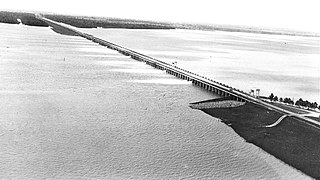
English: The Morganza Spillway was first opened in 1973, not to control flooding, but to relieve pressure on the en:Old River Control Complex
Deutsch: Der Morganza Spillway wurde erstmals 1973 geöffnet, um Druck auf die de:Old River Control Structure wegzunehmen. |
| Date | Spring 1973 |
| Source | US Army Corps of Engineers photo via http://www.ccshost.com/btnep_educators/client_files/editor_files/38%20False%20River-Morganza%20Spillway-Old%20River%20Control%20Structure.pdf |
| Author | U.S. Army Corps of Engineers. |
| Permission (Reusing this file) |
PD-USGOV-MILITARY-ARMY. |
| Camera location | | View this and other nearby images on: OpenStreetMap |
|---|
Licensing
This file is a work of a U.S. Army soldier or employee, taken or made as part of that person's official duties. As a work of the U.S. federal government, it is in the public domain in the United States.
|
 |
Wikipedia upload log
A Wikipedia description page is/was here. All following user names refer to en.wikipedia.
- 2011-05-09 04:55 Uruiamme 1351×758× (312055 bytes) {{Information |Description = The Morganza Spillway was first opened in 1973, not to control flooding, but to relieve pressure on the [[Old River Control Complex]] |Source = http://www.ccshost.com/btnep_educators/client_files/editor_files/38%20False%20River-Morganza%20Spillway-Old%20River%20Control%20Structure.pdf |Date = 1973 |Author = U.S. Army Corps of Engineers |Permission = |other_versions = }}
File history
Click on a date/time to view the file as it appeared at that time.
| Date/Time | Thumbnail | Dimensions | User | Comment | |
|---|---|---|---|---|---|
| current | 15:09, 15 May 2011 | | 1,351 × 758 (305 KB) | Matthiasb | {{Information |Description={{en|The Morganza Spillway was first opened in 1973, not to control flooding, but to relieve pressure on the w:en:Old River Control Complex}} {{de|Der Morganza Spillway wurde erstmals 1973 geöffnet, um Druck auf die [[:w: |
File usage
The following pages on the English Wikipedia use this file (pages on other projects are not listed):
Global file usage
The following other wikis use this file:
- Usage on de.wikipedia.org