
Size of this preview: 800 × 450 pixels. Other resolutions: 320 × 180 pixels | 640 × 360 pixels | 1,245 × 701 pixels.
Original file (1,245 × 701 pixels, file size: 526 KB, MIME type: image/jpeg)
| This is a file from the Wikimedia Commons. Information from its description page there is shown below. Commons is a freely licensed media file repository. You can help. |
Summary
| Description |
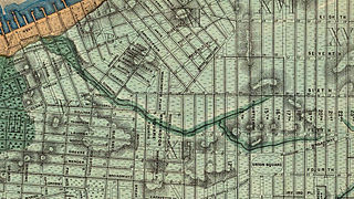
English: Topographical map showing approximate course of Minetta Creek, overlayed with street grid as of 1865, reproduced from Egbert Ludovicus Viele's "Sanitary & Topographical Map of the City and Island of New York" |
|||||||||||||||||||||||
| Date | ||||||||||||||||||||||||
| Source | Sanitary & Topographical Map of the City and Island of New York | |||||||||||||||||||||||
| Author |
|
|||||||||||||||||||||||

Area cropped from full-length map of Manhattan
Licensing
This media file is in the public domain in the United States. This applies to U.S. works where the copyright has expired, often because its first publication occurred prior to January 1, 1929, and if not then due to lack of notice or renewal. See this page for further explanation.
|
 | |
 |
This image might not be in the public domain outside of the United States; this especially applies in the countries and areas that do not apply the rule of the shorter term for US works, such as Canada, Mainland China (not Hong Kong or Macao), Germany, Mexico, and Switzerland. The creator and year of publication are essential information and must be provided. See Wikipedia:Public domain and Wikipedia:Copyrights for more details.
|
| Annotations | This image is annotated: View the annotations at Commons |
File history
Click on a date/time to view the file as it appeared at that time.
| Date/Time | Thumbnail | Dimensions | User | Comment | |
|---|---|---|---|---|---|
| current | 17:08, 3 July 2012 | | 1,245 × 701 (526 KB) | Kosboot |
File usage
The following pages on the English Wikipedia use this file (pages on other projects are not listed):