Size of this preview: 573 × 600 pixels. Other resolutions: 229 × 240 pixels | 459 × 480 pixels | 734 × 768 pixels | 978 × 1,024 pixels | 1,506 × 1,576 pixels.
Original file (1,506 × 1,576 pixels, file size: 269 KB, MIME type: image/png)
| This is a file from the Wikimedia Commons. Information from its description page there is shown below. Commons is a freely licensed media file repository. You can help. |
| Description |
|
| Date | |
| Source |
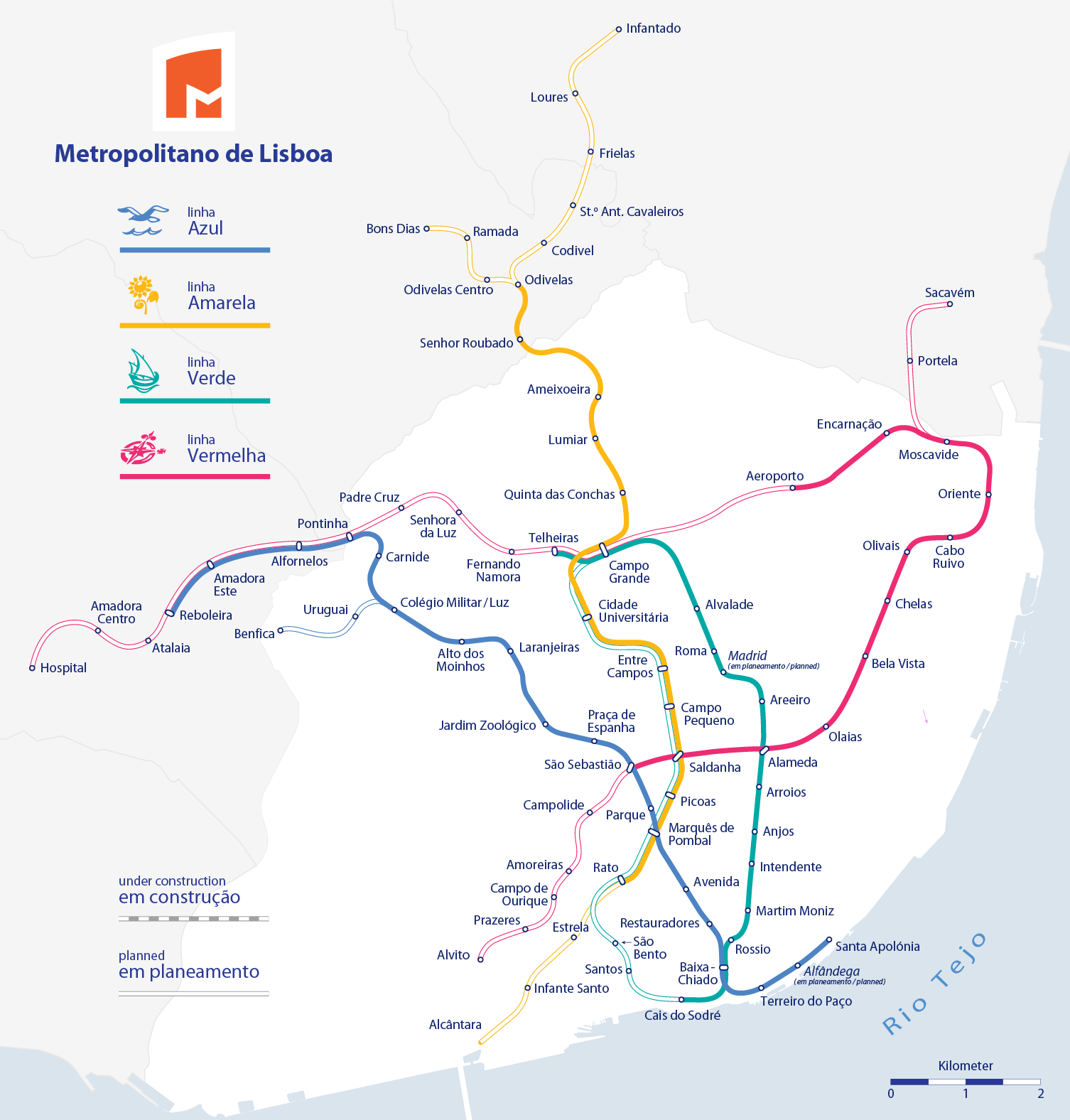
Self made, using the information from and using the following logos:
Created with Adobe Illustrator 12.0 If you ask for, I will give you the .ai-file or I'll correct it or create other language versions. |
| Author | Maximilian Dörrbecker (Chumwa) |
| Permission (Reusing this file) |
I, the copyright holder of this work, hereby publish it under the following license: This file is licensed under the Creative Commons Attribution-Share Alike 2.5 Generic license.
Sie dürfen das Bild zu den folgenden Bedingungen nutzen:
|
| Other versions |
|
.png)

.png)


File history
Click on a date/time to view the file as it appeared at that time.
| Date/Time | Thumbnail | Dimensions | User | Comment | |
|---|---|---|---|---|---|
| current | 18:01, 27 May 2016 | | 1,506 × 1,576 (269 KB) | Chumwa | Verlängerung nach Reboleira eröffnet |
| 04:51, 31 July 2012 |  | 1,506 × 1,576 (269 KB) | Chumwa | Strecke zum Flughafen ist jetzt eröffnet | |
| 04:50, 31 July 2012 |  | 1,506 × 1,576 (269 KB) | Chumwa | Strecke zum Flughafen ist jetzt eröffnet | |
| 21:05, 24 January 2011 |  | 1,506 × 1,576 (287 KB) | Chumwa | Estrela soll nun über die gelbe Linie von Rato aus erschlossen werden | |
| 08:15, 25 October 2009 |  | 1,506 × 1,576 (286 KB) | Chumwa | Amadora Este - Reboleira als im Bau befindlich ergänzt | |
| 16:19, 24 October 2009 |  | 1,506 × 1,576 (285 KB) | Chumwa | diverse Korrekturen (vielen Dank an jcornelius für die Hinweise!) | |
| 18:41, 22 October 2009 |  | 1,506 × 1,576 (274 KB) | Chumwa | update | |
| 00:12, 21 October 2009 |  | 978 × 957 (99 KB) | Javitomad | ¿Oriente-Aeroporto? (and repairing Alameda-SãoSebastião drawing) | |
| 20:39, 2 September 2009 |  | 978 × 957 (103 KB) | João P. M. Lima | linhas planeadas já não correspondem exactamente ao apresentado no plano de expansão 2010/2020, retiro essas linhas, pois também já existe um mapa para as expansões (obras em curso ficam no mapa) | |
| 15:53, 29 August 2009 |  | 978 × 957 (117 KB) | João P. M. Lima | carrego outra vez porque acho que à primeira não funcionou |
File usage
The following pages on the English Wikipedia use this file (pages on other projects are not listed):
Global file usage
The following other wikis use this file:
- Usage on ca.wikipedia.org
- Usage on de.wikipedia.org
- Usage on eo.wikipedia.org
- Usage on es.wikipedia.org
- Usage on fi.wikipedia.org
- Usage on fr.wikipedia.org
- Usage on hu.wikipedia.org
- Usage on ja.wikipedia.org
- Usage on ka.wikipedia.org
- Usage on nl.wikipedia.org
- Usage on pt.wikipedia.org
- Usage on ru.wikipedia.org
- Usage on sv.wikipedia.org
- Usage on tl.wikipedia.org
- Usage on tr.wikipedia.org
- Usage on uk.wikipedia.org