
Size of this preview: 518 × 599 pixels. Other resolutions: 207 × 240 pixels | 415 × 480 pixels | 664 × 768 pixels | 885 × 1,024 pixels | 1,302 × 1,506 pixels.
Original file (1,302 × 1,506 pixels, file size: 544 KB, MIME type: image/jpeg)
| This is a file from the Wikimedia Commons. Information from its description page there is shown below. Commons is a freely licensed media file repository. You can help. |
Summary
| Description |
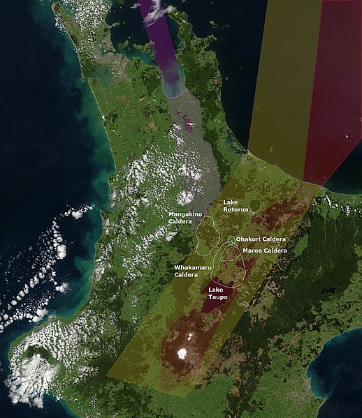
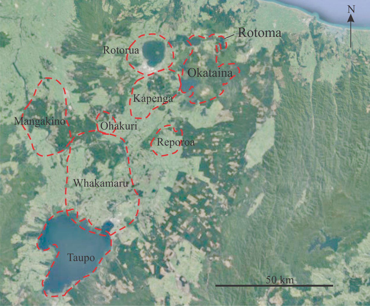
English: Whakamaru Caldera approximate location and boundaries north of Lake Taupo. It must be emphasised that it has proved very challenging to define caldera boundaries in these areas prior to 25000 years ago and the various original sources show some variation of inferred and even definite boundaries, often with assignment to adjacent volcanoes as time frames of activity overlap. The more recent Maroa Caldera is contained within it and the Ohakuri Caldera which had a paired eruption with the Rotorua Caldera is to its north. To its west is the oldest Mangakino Caldera and indeed the area on the map showing separation may not be the case as these are old volcanoes of the old Taupō Rift (yellow shading). Also shown is the modern Taupo Rift (red shading), Hauraki Rift (purple shading) and landmarks of Lake Taupo and Lake Rotorua. |
| Date | |
| Source | Own work |
| Author | ChaseKiwi |
- Original map improved once a copy of Gravley's 2004 PhD was found. It had been quoted repeatly as unpublished but is a rich source as a literature review and with potential location uncertainties and it is apparent that any location work on caldera boundaries based on work prior to this has to be re-interpreted ChaseKiwi (talk) 18:17, 17 August 2022 (UTC)
Annotations based on:
- The Ohakuri pyroclastic deposits and the evolution of the Rotorua-Ohakuri volcanotectonic depression (2004). Retrieved on 2022-08-17.
- S. J. Barker et al. Taupō: an overview of New Zealand's youngest supervolcano July 2020 New Zealand Journal of Geology and Geophysics 64(6):1-27
- J. W. Cole, K. D. Spinks. Caldera volcanism and rift structure in the Taupo Volcanic Zone, New Zealand DOI: https://doi.org/10.1144/SP327.2
- Groundwater resource characterisation in the Waikato River catchment for Healthy Rivers Project 2015 (for geological map)
- (2014). "Extraction, Storage and Eruption of Multiple Isolated Magma Batches in the Paired Mamaku and Ohakuri Eruption, Taupo Volcanic Zone, New Zealand". Journal of Petrology 55 (8): 1653–1684. DOI:10.1093/petrology/egu038.
- Geological Digressions:Block and ash flow deposits in outcrop March 2022
- QMAP Rotorua
- The Taupo Volcanic Zone – Part 3 2012
- Quartz Zoning and the Pre-eruptive Evolution of the ~340 ka Whakamaru Magma Systems, New Zealand January 2011 Contributions to Mineralogy and Petrology 163(1):87-107
- BASEMENT GEOLOGY AND STRUCTURE OF TVZ GEOTHERMAL FIELDS, NEW ZEALAND, C. Peter Wood (1996)
- Caldera volcanoes of the Taupo Volcanic Zone, New Zealand C. J. N. Wilson, A. M. Rogan, I. E. M. Smith, D. J. Northey, I. A. Nairn, B. F. Houghton 1984
DOI:10.1007/s00410-011-0660-1
This image is a derivative work of the following images:
| This image is in the public domain because it is a screenshot from NASA’s globe software World Wind using a public domain layer, such as Blue Marble, MODIS, Landsat, SRTM, USGS or GLOBE.
|
 |
Licensing
I, the copyright holder of this work, hereby publish it under the following license:
This file is licensed under the Creative Commons Attribution-Share Alike 4.0 International license.
- You are free:
- to share – to copy, distribute and transmit the work
- to remix – to adapt the work
- Under the following conditions:
- attribution – You must give appropriate credit, provide a link to the license, and indicate if changes were made. You may do so in any reasonable manner, but not in any way that suggests the licensor endorses you or your use.
- share alike – If you remix, transform, or build upon the material, you must distribute your contributions under the same or compatible license as the original.
File history
Click on a date/time to view the file as it appeared at that time.
| Date/Time | Thumbnail | Dimensions | User | Comment | |
|---|---|---|---|---|---|
| current | 18:26, 17 August 2022 | | 1,302 × 1,506 (544 KB) | ChaseKiwi | Inferred caldera outlines updated by Gravley 2004 analysis |
| 21:19, 16 August 2022 |  | 1,302 × 1,506 (544 KB) | ChaseKiwi | Uploaded while editing "Whakamaru caldera" on en.wikipedia.org |
File usage
The following pages on the English Wikipedia use this file (pages on other projects are not listed):