
Size of this PNG preview of this SVG file: 515 × 600 pixels. Other resolutions: 206 × 240 pixels | 412 × 480 pixels | 660 × 768 pixels | 879 × 1,024 pixels | 1,759 × 2,048 pixels | 761 × 886 pixels.
Original file (SVG file, nominally 761 × 886 pixels, file size: 180 KB)
| This is a file from the Wikimedia Commons. Information from its description page there is shown below. Commons is a freely licensed media file repository. You can help. |
Summary
| Description |
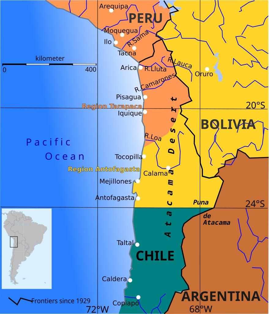
English: Boundary before war (colored areas) and after the War of the Pacific (1879-1883) (black and red lines)
Peruvian territories before the war
Bolivian territories before the war
Chilean territories before the war
Peru-Bolivia Boundary in Atacama Desert according to File:Departamento moquegua 1865.JPG Argentina-Bolivia Boundary in Puna de Atacama and Tarija was contested according to File:MPazSoldan.1888-2xChile.djvu |
||||||
| Date | |||||||
| Source | Own work | ||||||
| Author | Createaccount | ||||||
| Permission (Reusing this file) |
I, the copyright holder of this work, hereby publish it under the following licenses: This file is licensed under the Creative Commons Attribution-Share Alike 3.0 Unported license.
You may select the license of your choice. |
||||||
| Other versions | File:Wotp.de.svg |

File history
Click on a date/time to view the file as it appeared at that time.
| Date/Time | Thumbnail | Dimensions | User | Comment | |
|---|---|---|---|---|---|
| current | 13:33, 9 April 2015 | | 761 × 886 (180 KB) | Keysanger | gradient instead of white line at the coast |
| 13:56, 29 January 2015 |  | 761 × 886 (181 KB) | Keysanger | margin cropped. | |
| 13:43, 29 January 2015 |  | 760 × 887 (182 KB) | Keysanger | Back to version with frontiers as for 1929 because they are known and accepted. It is almost impossible to draw all frontiers, at every time for every point of view | |
| 13:27, 7 November 2014 |  | 760 × 887 (172 KB) | Keysanger | Argentina+Bolivia colors for disputed zone | |
| 14:14, 4 November 2014 |  | 760 × 887 (172 KB) | Keysanger | Puna de Atacama was a disputed zone and also Tarija. | |
| 17:29, 12 February 2013 |  | 760 × 887 (170 KB) | Citypeek | removal border and removal legenda (to be added on the page itself) | |
| 19:47, 5 October 2009 |  | 804 × 1,026 (230 KB) | Keysanger | Now Puna de Atacam reaches ca. 26°S | |
| 12:10, 4 October 2009 |  | 804 × 1,026 (232 KB) | Keysanger | Text "Boundary after war" changed to "Chilean boundary after war" | |
| 18:01, 23 September 2009 |  | 804 × 1,026 (232 KB) | Keysanger | Title wasn't necessary, Margin was too big | |
| 23:46, 1 July 2009 |  | 744 × 1,052 (225 KB) | Keysanger | coordinates a white difuse coast line in background |
File usage
The following pages on the English Wikipedia use this file (pages on other projects are not listed):
Global file usage
The following other wikis use this file:
- Usage on ar.wikipedia.org
- Usage on ast.wikipedia.org
- Usage on az.wikipedia.org
- Usage on ba.wikipedia.org
- Usage on bg.wikipedia.org
- Usage on br.wikipedia.org
- Usage on ca.wikipedia.org
- Usage on cs.wikipedia.org
- Usage on da.wikipedia.org
- Usage on es.wikipedia.org
- Usage on fi.wikipedia.org
- Usage on fr.wiktionary.org
- Usage on hr.wikipedia.org
- Usage on hy.wikipedia.org
- Usage on io.wikipedia.org
- Usage on ja.wikipedia.org
- Usage on mk.wikipedia.org
- Usage on no.wikipedia.org
- Usage on pt.wikipedia.org
- Usage on sr.wikipedia.org
- Usage on sv.wikipedia.org
- Usage on zh.wikipedia.org