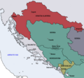
Map_of_the_Kingdom_of_Croatia-Slavonia_(1885).png (542 × 502 pixels, file size: 31 KB, MIME type: image/png)
File history
Click on a date/time to view the file as it appeared at that time.
| Date/Time | Thumbnail | Dimensions | User | Comment | |
|---|---|---|---|---|---|
| current | 11:11, 11 October 2009 |  | 542 × 502 (31 KB) | DIREKTOR | {{Information |Description={{en|1=Map of the Kingdom of Croatia Slavonia cca. 1885. The Kingdom was a part of Transleithanian Austria-Hungary, the Kingdom of Hungary (Lands of the Crown of St. Stephen).}} |Source={{own}} |Author=DIREKTOR |
| 11:07, 11 October 2009 |  | 542 × 502 (33 KB) | DIREKTOR | {{Information |Description={{en|1=Map of the Kingdom of Croatia Slavonia cca. 1885. The Kingdom was a part of Transleithanian Austria-Hungary, the Kingdom of Hungary (Lands of the Crown of St. Stephen).}} |Source={{own}} |Author=DIREKTOR | |
| 21:31, 10 October 2009 |  | 542 × 502 (33 KB) | DIREKTOR | {{Information |Description={{en|1=Map of the Kingdom of Croatia Slavonia cca. 1885. The Kingdom was a part of Transleithanian Austria-Hungary, the Kingdom of Hungary (Lands of the Crown of St. Stephen).}} |Source={{own}} |Author=DIREKTOR |
File usage
The following 2 pages use this file:
Global file usage
The following other wikis use this file:
- Usage on ar.wikipedia.org
- Usage on bs.wikipedia.org
- Usage on fr.wikipedia.org
- Usage on ga.wikipedia.org
- Usage on he.wikipedia.org
- Usage on id.wikipedia.org
- Usage on ka.wikipedia.org
- Usage on ko.wikipedia.org
- Usage on ku.wikipedia.org
- Usage on mt.wikipedia.org
- Usage on pt.wikipedia.org
- Usage on sk.wikipedia.org
- Usage on sr.wikipedia.org
- Usage on tr.wikipedia.org
- Usage on uk.wikipedia.org
- Usage on www.wikidata.org
