
Size of this preview: 800 × 582 pixels. Other resolutions: 320 × 233 pixels | 640 × 465 pixels | 1,024 × 745 pixels | 1,280 × 931 pixels | 2,027 × 1,474 pixels.
Original file (2,027 × 1,474 pixels, file size: 353 KB, MIME type: image/jpeg)
| This is a file from the Wikimedia Commons. Information from its description page there is shown below. Commons is a freely licensed media file repository. You can help. |
Summary
| Description |
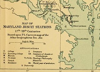
English: A map of Jesuit stations in Maryland from the 17th to the 19th centuries, showing the locations of Jesuit plantations, farms, and schools, including Bohemia, Frederick, Georgetown, Leonardtown, Newtown, Port Tobacco, St. Inigoes, St. Joseph, St. Thomas, Washington, White Marsh, and Woodstock. |
| Date | |
| Source | Georgetown Slavery Archive https://slaveryarchive.georgetown.edu/items/show/57 |
| Author | Georgetown Slavery Archive |
| Other versions |

.jpg)
.jpg&action=edit&redlink=1)
.jpg)
Licensing
This work is in the public domain in the United States because it was published (or registered with the U.S. Copyright Office) before January 1, 1929.
Public domain works must be out of copyright in both the United States and in the source country of the work in order to be hosted on the Commons. If the work is not a U.S. work, the file must have an additional copyright tag indicating the copyright status in the source country.
Note: This tag should not be used for sound recordings. |
File history
Click on a date/time to view the file as it appeared at that time.
| Date/Time | Thumbnail | Dimensions | User | Comment | |
|---|---|---|---|---|---|
| current | 23:18, 2 February 2018 | | 2,027 × 1,474 (353 KB) | Lhblossom1936 | File:MAP OF MARYLAND JESUIT STATIONS, 17TH-19TH CENTURIES.pdf cropped 12 % horizontally and 61 % vertically using CropTool with precise mode. |
File usage
The following pages on the English Wikipedia use this file (pages on other projects are not listed):
.jpg)