
Size of this preview: 748 × 600 pixels. Other resolutions: 300 × 240 pixels | 599 × 480 pixels | 958 × 768 pixels | 1,278 × 1,024 pixels | 2,213 × 1,774 pixels.
Original file (2,213 × 1,774 pixels, file size: 4.58 MB, MIME type: image/png)
| This is a file from the Wikimedia Commons. Information from its description page there is shown below. Commons is a freely licensed media file repository. You can help. |
Summary
| Description |
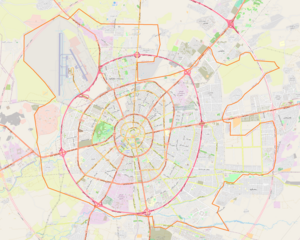
English: Map of Arbil
Geographic limits of the map:
Nederlands: Plattegrond van Arbil
Geografische begrenzing van de plattegrond:
|
| Date | |
| Source | OpenStreetMap |
| Author | OpenStreetMap contributors |
| Permission (Reusing this file) |
All OpenStreetMap data and maps are Creative Commons "CC-BY-SA 2.0" licensed |
Licensing
This file is licensed under the Creative Commons Attribution-Share Alike 2.0 Generic license.
- You are free:
- to share – to copy, distribute and transmit the work
- to remix – to adapt the work
- Under the following conditions:
- attribution – You must give appropriate credit, provide a link to the license, and indicate if changes were made. You may do so in any reasonable manner, but not in any way that suggests the licensor endorses you or your use.
- share alike – If you remix, transform, or build upon the material, you must distribute your contributions under the same or compatible license as the original.
File history
Click on a date/time to view the file as it appeared at that time.
| Date/Time | Thumbnail | Dimensions | User | Comment | |
|---|---|---|---|---|---|
| current | 14:57, 17 August 2022 | | 2,213 × 1,774 (4.58 MB) | Smat | new map |
| 22:37, 2 March 2011 |  | 875 × 994 (166 KB) | Zoeperkoe | {{Information |Description ={{en|1=Map of Arbil}} {{nl|1=Plattegrond van Arbil}} |Source =[http://openstreetmap.org OpenStreetMap] |Author =Zoeperkoe |Date =2011-03-02 |Permission =See below. |other_vers |
File usage
The following pages on the English Wikipedia use this file (pages on other projects are not listed):
Global file usage
The following other wikis use this file:
- Usage on ar.wikipedia.org
- Usage on ceb.wikipedia.org
- Usage on ckb.wikipedia.org
- Usage on fa.wikipedia.org
- Usage on fr.wikipedia.org
- Usage on he.wikipedia.org
- Usage on kn.wikipedia.org
- Usage on pl.wikipedia.org
- Usage on pl.wikibooks.org
- Usage on si.wikipedia.org
- Usage on tr.wikipedia.org
- Usage on uz.wikipedia.org
- Usage on war.wikipedia.org