Size of this preview: 345 × 600 pixels. Other resolutions: 138 × 240 pixels | 276 × 480 pixels.
Original file (800 × 1,391 pixels, file size: 161 KB, MIME type: image/png)
| This is a file from the Wikimedia Commons. Information from its description page there is shown below. Commons is a freely licensed media file repository. You can help. |
Summary
| Description |
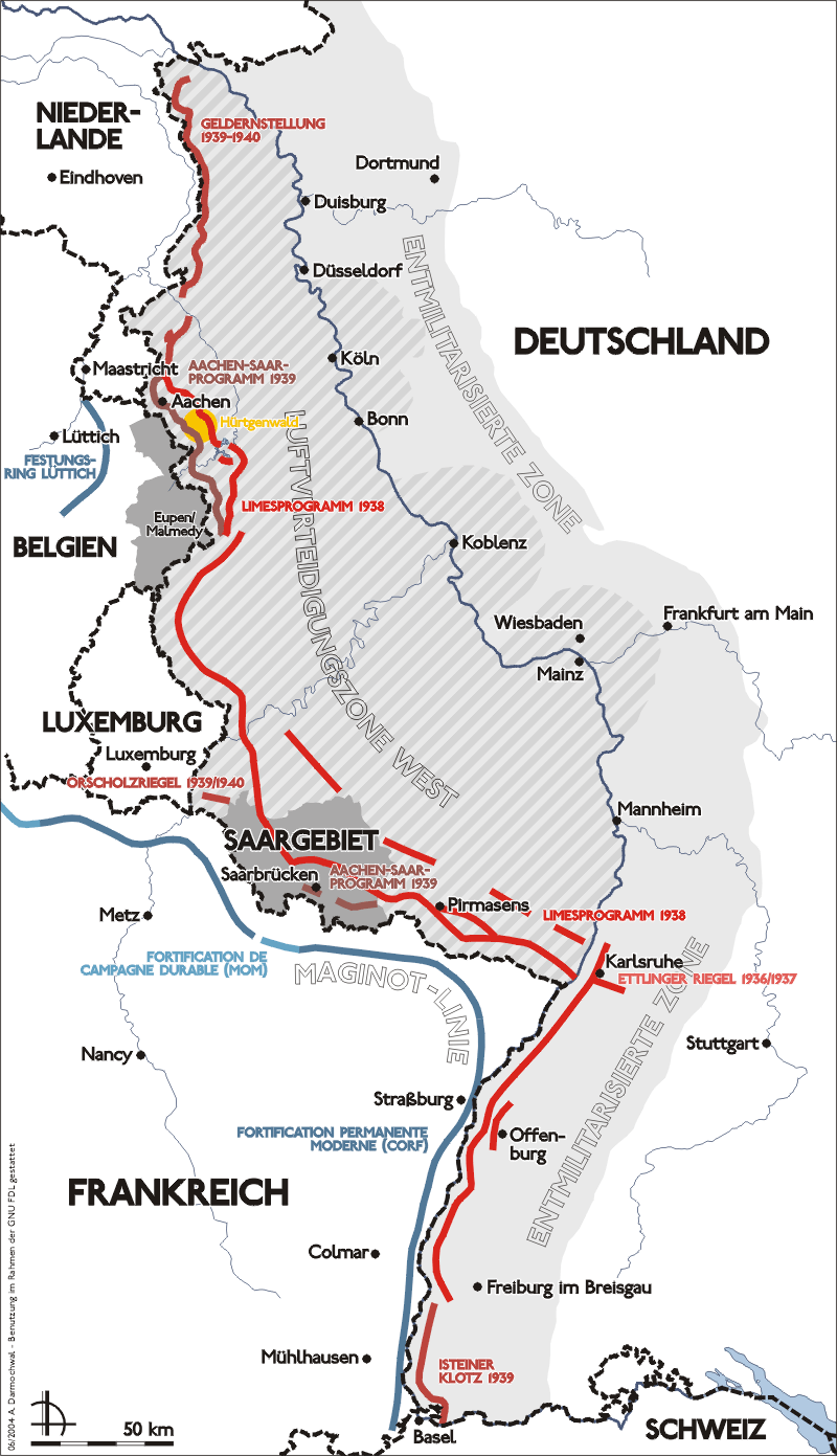
Deutsch: Darstellung zeigt Lage, Verlauf und bauliche Entwicklung des Westwalls. |
| Date | |
| Source | Own work |
| Author | Sansculotte |
| Permission (Reusing this file) |
Zeichnung erstellt 2004 von Sansculotte. Bild ist unter der GNU FDL zur weiteren Verwendung freigegeben.
|

|
This military map image could be re-created using vector graphics as an SVG file. This has several advantages; see Commons:Media for cleanup for more information. If an SVG form of this image is available, please upload it and afterwards replace this template with
{{vector version available|new image name}}.
It is recommended to name the SVG file “Karte westwall.svg”—then the template Vector version available (or Vva) does not need the new image name parameter. |
|
Licensing
I, the copyright holder of this work, hereby publish it under the following licenses:

|
Permission is granted to copy, distribute and/or modify this document under the terms of the GNU Free Documentation License, Version 1.2 or any later version published by the Free Software Foundation; with no Invariant Sections, no Front-Cover Texts, and no Back-Cover Texts. A copy of the license is included in the section entitled GNU Free Documentation License. |
| This file is licensed under the Creative Commons Attribution-Share Alike 3.0 Unported license. | ||
| ||
| This licensing tag was added to this file as part of the GFDL licensing update. |
This file is licensed under the Creative Commons Attribution-Share Alike 2.0 Germany license.
- You are free:
- to share – to copy, distribute and transmit the work
- to remix – to adapt the work
- Under the following conditions:
- attribution – You must give appropriate credit, provide a link to the license, and indicate if changes were made. You may do so in any reasonable manner, but not in any way that suggests the licensor endorses you or your use.
- share alike – If you remix, transform, or build upon the material, you must distribute your contributions under the same or compatible license as the original.

You may select the license of your choice.
Original upload log
(All user names refer to de.wikipedia)
- (Löschen) (Aktuell) 18:56, 31. Aug 2004 . . Sansculotte (164472 Byte) (fehler korr.)
- (Löschen) (Zurücksetzen) 14:56, 29. Jun 2004 . . Sansculotte (164346 Byte) (upd)
- (Löschen) (Zurücksetzen) 04:40, 29. Jun 2004 . . Sansculotte (159356 Byte)
- (Löschen) (Zurücksetzen) 04:14, 29. Jun 2004 . . Sansculotte (158019 Byte)
- (Löschen) (Zurücksetzen) 00:48, 29. Jun 2004 . . Sansculotte (131228 Byte) (eigene Aufnahme, Nutzung gestattet unter der GNU/FDL und der cc-by-sa)
File history
Click on a date/time to view the file as it appeared at that time.
| Date/Time | Thumbnail | Dimensions | User | Comment | |
|---|---|---|---|---|---|
| current | 10:15, 17 September 2005 | | 800 × 1,391 (161 KB) | Saperaud~commonswiki | *Darstellung zeigt Lage, Verlauf und bauliche Entwicklung des Westwalls. *Zeichnung erstellt 2004 von Benutzer:Sansculotte. Bild ist unter der GNU FDL zur weiteren Verwendung freigegeben. *'''Quellenangabe und Beleg an [mailto:sansculotte@despamme |
File usage
The following pages on the English Wikipedia use this file (pages on other projects are not listed):
Global file usage
The following other wikis use this file:
- Usage on ar.wikipedia.org
- Usage on az.wikipedia.org
- Usage on be.wikipedia.org
- Usage on bg.wikipedia.org
- Usage on br.wikipedia.org
- Usage on ca.wikipedia.org
- Usage on da.wikipedia.org
- Usage on de.wikipedia.org
- Usage on eo.wikipedia.org
- Usage on es.wikipedia.org
- Usage on et.wikipedia.org
- Usage on fa.wikipedia.org
- Usage on fr.wikipedia.org
- Usage on fr.wiktionary.org
- Usage on he.wikipedia.org
- Usage on hr.wikipedia.org
- Usage on hu.wikipedia.org
- Usage on it.wikipedia.org
- Usage on ja.wikipedia.org
- Usage on ka.wikipedia.org
- Usage on ko.wikipedia.org
- Usage on lb.wikipedia.org
- Usage on ms.wikipedia.org
- Usage on no.wikipedia.org
- Usage on pl.wikipedia.org
- Usage on pt.wikipedia.org
- Usage on ro.wikipedia.org
- Usage on ru.wikipedia.org
- Usage on sk.wikipedia.org
- Usage on sr.wikipedia.org
- Usage on sv.wikipedia.org
View more global usage of this file.