
Size of this PNG preview of this SVG file: 622 × 600 pixels. Other resolutions: 249 × 240 pixels | 498 × 480 pixels | 797 × 768 pixels | 1,062 × 1,024 pixels | 2,124 × 2,048 pixels | 1,033 × 996 pixels.
Original file (SVG file, nominally 1,033 × 996 pixels, file size: 2.94 MB)
| This is a file from the Wikimedia Commons. Information from its description page there is shown below. Commons is a freely licensed media file repository. You can help. |
Summary
| Description |
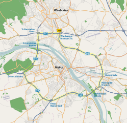
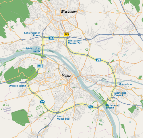
English: "Mainzer Ring" (Mainz Ring Road), Germany |
||||||||||||
| Date | |||||||||||||
| Source | Own work | ||||||||||||
| Author | NordNordWest | ||||||||||||
| Permission (Reusing this file) |
|

|
This map has been made or improved in the German Kartenwerkstatt (Map Lab). You can propose maps to improve as well.
|
| Annotations | This image is annotated: View the annotations at Commons |
File history
Click on a date/time to view the file as it appeared at that time.
| Date/Time | Thumbnail | Dimensions | User | Comment | |
|---|---|---|---|---|---|
| current | 15:35, 20 February 2010 | | 1,033 × 996 (2.94 MB) | NordNordWest | == {{int:filedesc}} == {{Information |Description= {{de|Mainzer Ring}} {{en|"Mainzer Ring" (Mainz Ring Road), Germany}} |Source={{Own}} |Date=2010-02-20 |Author={{U|NordNordWest}} |Permission={{OpenStreetMap}} |other_versions= }} {{Ka |
File usage
The following pages on the English Wikipedia use this file (pages on other projects are not listed):
Global file usage
The following other wikis use this file:
- Usage on de.wikipedia.org
- Usage on de.wikivoyage.org
- Usage on fr.wikipedia.org
- Usage on fr.wikivoyage.org
- Usage on hu.wikipedia.org
- Usage on it.wikipedia.org
- Usage on ja.wikipedia.org
- Usage on nl.wikipedia.org
- Usage on www.wikidata.org