
Size of this preview: 800 × 450 pixels. Other resolutions: 320 × 180 pixels | 640 × 360 pixels | 1,024 × 576 pixels | 1,280 × 720 pixels | 2,560 × 1,440 pixels | 5,136 × 2,888 pixels.
Original file (5,136 × 2,888 pixels, file size: 2.51 MB, MIME type: image/jpeg)
 | Do not copy this file to Wikimedia Commons. Commons no longer accepts the GNU Free Documentation License. |
Summary edit
| Description |
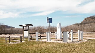
English: 1849 iron post near the Mississippi River marking the official eastern starting point of the border between Iowa and Minnesota, surrounded by a low fence with interpretive signs nearby and railroad tracks and hills in the background. The site is listed on the U.S. National Register of Historic Places. |
|---|---|
| Source |
Own work |
| Date |
2020-04-05 |
| Author |
Self-created photograph by Jonathunder |
| Permission (Reusing this file) |
See below.
|
Licensing edit
 | Jonathunder, the creator of this work, has granted (or hereby grants) permission to copy, distribute and/or modify this document under the terms of the GNU Free Documentation License, Version 1.2 or any later version published by the Free Software Foundation; with no Invariant Sections, no Front-Cover Texts, and no Back-Cover Texts. A copy of the license is included in the section entitled "GNU Free Documentation License". |
File history
Click on a date/time to view the file as it appeared at that time.
| Date/Time | Thumbnail | Dimensions | User | Comment | |
|---|---|---|---|---|---|
| current | 01:44, 6 April 2020 | | 5,136 × 2,888 (2.51 MB) | Jonathunder (talk | contribs) | {{Do not move to Commons|reason=Commons no longer accepts the GNU Free Documentation License.}} == Summary == {{Information |Description={{NRHP|76000732}} {{en|1=1849 iron post near the Mississippi River marking the official eastern starting point of the border between Iowa and Minnesota, surrounded by a low fence with interpretive signs nearby and railroad tracks and hills in the background. The site is listed on the U.S. National Register of Historic Places.}} |Source={{own}} |Author=Se... |
You cannot overwrite this file.
File usage
The following pages on the English Wikipedia use this file (pages on other projects are not listed):