
Original file (1,362 × 1,170 pixels, file size: 632 KB, MIME type: image/png)
Summary edit
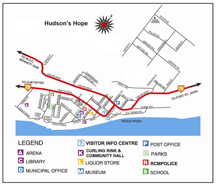
Image shows the street layout of Hudson's Hope, British Columbia, along with the Peace River flowing northeast from the WAC Bennett Dam.
Licensing edit
Used with permission, see Wikipedia:Successful requests for permission/Hudson's Hope, BC. Source: Hello North
 | Permission is granted to copy, distribute and/or modify this document under the terms of the GNU Free Documentation License, Version 1.2 or any later version published by the Free Software Foundation; with no Invariant Sections, no Front-Cover Texts, and no Back-Cover Texts. Subject to disclaimers. |
| This work is licensed under the Creative Commons Attribution-ShareAlike 3.0 License. This licensing tag was added to this file as part of the GFDL licensing update. |
 | This file is a candidate to be copied to Wikimedia Commons.
Any user may perform this transfer; refer to Wikipedia:Moving files to Commons for details. If this file has problems with attribution, copyright, or is otherwise ineligible for Commons, then remove this tag and DO NOT transfer it; repeat violators may be blocked from editing. Other Instructions
| ||
| |||
File history
Click on a date/time to view the file as it appeared at that time.
| Date/Time | Thumbnail | Dimensions | User | Comment | |
|---|---|---|---|---|---|
| current | 00:48, 25 March 2006 | | 1,362 × 1,170 (632 KB) | Maclean25 (talk | contribs) | Street map of Hudson's Hope, British Columbia |
You cannot overwrite this file.