No higher resolution available.
Hood_Canal_fault.png (186 × 294 pixels, file size: 105 KB, MIME type: image/png)
| This is a file from the Wikimedia Commons. Information from its description page there is shown below. Commons is a freely licensed media file repository. You can help. |
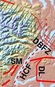
| Description | Location of Hood Canal fault, Dabob Bay fault zone, Dewatto lineament (Puget Lowland). |
| Date | |
| Source | Own work. Excerpt from File:Puget Sound faults.png (revised). |
| Author | J. Johnson |
| Permission (Reusing this file) |
This file is licensed under the Creative Commons Attribution 3.0 Unported license.
|
File history
Click on a date/time to view the file as it appeared at that time.
| Date/Time | Thumbnail | Dimensions | User | Comment | |
|---|---|---|---|---|---|
| current | 00:06, 17 January 2014 | | 186 × 294 (105 KB) | J. Johnson | Tracking changes in main map from which this excerpt is taken. Mainly "TF" to "DL". |
| 23:14, 31 December 2013 |  | 239 × 393 (115 KB) | J. Johnson | {{Information |Description= Location of Hood Canal fault and Dabob Bay fault zone (Puget Lowland). |Source= {{own}}. Excerpt from File:Puget Sound faults.png (revised). |Date= 2013-12-31 |Author= J. Johnson |Permission={{cc-by-3.0}} |other_version... |
File usage
The following pages on the English Wikipedia use this file (pages on other projects are not listed):
Global file usage
The following other wikis use this file:
- Usage on de.wikipedia.org