Original file (2,400 × 2,700 pixels, file size: 1.38 MB, MIME type: image/jpeg)
Key edit
Relocated or Demolished Houses edit
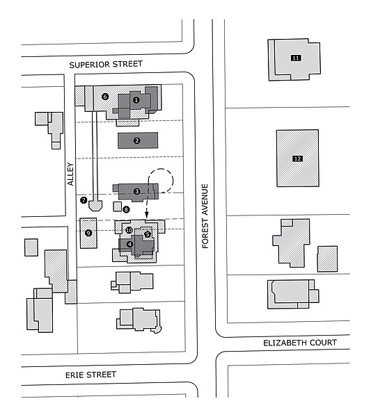
1. First Nathan G. Moore House; purchased by Moore in 1886, moved 3 lots west on Superior in 1895.
2. Unknown; property bought by Moore in 1891 after house was destroyed by fire sometime prior. House footprint is approximate as no known records of the structure's design exist.
3. Frank S. Gray House; built in 1884, purchased by Moore in 1900, moved south and remodeled in 1906 (see #5).
4. D.L. McDaniels House; bought by Moore in 1905, demolished in 1906.
5. Relocated Frank S. Gray House (footprint prior to remodel - see #10).
Current Structures edit
6. Nathan G. Moore Residence; built in 1895, burned 1922, subsequently rebuilt.
7. Pergola and pavilion; built c. 1906, demolished, partially reconstructed in 2009.
8. 1893 World's Columbian Exposition ticket booth; purchased by Moore, restored by Tom and Irene DeCaro after 1975.
9. Hills House Garage; built 1978.
10. Edward R. Hills House; remodeled from Frank S. Gray house in 1906, damaged by fire in 1976, subsequently rebuilt.
Nearby Frank Lloyd Wright Houses edit
11. William H. Copeland House; built in 1873, remodeled in 1909.
12. Arthur Heurtley House; built in 1902.
Summary edit
| Description |
This map / diagram shows the development of the Nathan G. Moore estate from 1891 until 1946 and documentation of the transformation of the Frank Gray house into the Edward R. Hills House. |
|---|---|
| Source |
Created by Fox69 based on diagrams and information from Jack Lesniak, 1895 Sanborn Insurance Maps, and recent satellite imagery. |
| Date |
31 March 2010 |
| Author | |
| Permission (Reusing this file) |
See below.
|
Licensing edit
| This work is licensed under the Creative Commons Attribution-ShareAlike 3.0 License. |
 | This file is a candidate to be copied to Wikimedia Commons.
Any user may perform this transfer; refer to Wikipedia:Moving files to Commons for details. If this file has problems with attribution, copyright, or is otherwise ineligible for Commons, then remove this tag and DO NOT transfer it; repeat violators may be blocked from editing. Other Instructions
| ||
| |||
File history
Click on a date/time to view the file as it appeared at that time.
| Date/Time | Thumbnail | Dimensions | User | Comment | |
|---|---|---|---|---|---|
| current | 03:17, 1 April 2010 |  | 2,400 × 2,700 (1.38 MB) | Fox69 (talk | contribs) | {{Information |Description = This map/diagram shows the development of the Nathan G. Moore estate from 1891 until 1946 and documentation of the transformation of the Frank Gray house into the Edward R. Hills House. | |
You cannot overwrite this file.