
Size of this preview: 463 × 599 pixels. Other resolutions: 185 × 240 pixels | 371 × 480 pixels | 593 × 768 pixels | 791 × 1,024 pixels | 1,582 × 2,048 pixels | 6,800 × 8,800 pixels.
Original file (6,800 × 8,800 pixels, file size: 8.22 MB, MIME type: image/jpeg)
| This is a file from the Wikimedia Commons. Information from its description page there is shown below. Commons is a freely licensed media file repository. You can help. |
Summary
| Description |
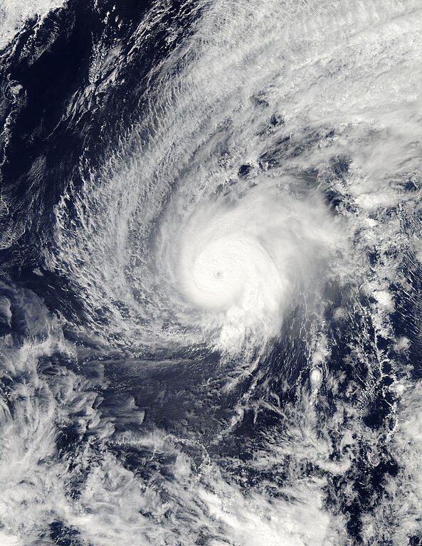
English: Typhoon Higos shortly before peak intensity and north-northeast of Chuuk on February 10, 2015. Español: El tifón Higos antes de alcanzar su pico de intensidad localizado al norte-noreste de Chuuk el 10 de febrero de 2015. |
| Date | |
| Source | http://rapidfire.sci.gsfc.nasa.gov/cgi-bin/imagery/single.cgi?image=Higos.A2015041.0310.2km.jpg |
| Author | NASA’s Aqua satellite |
Licensing
| This file is in the public domain in the United States because it was solely created by NASA. NASA copyright policy states that "NASA material is not protected by copyright unless noted". (See Template:PD-USGov, NASA copyright policy page or JPL Image Use Policy.) | ||
 |
Warnings:
|
File history
Click on a date/time to view the file as it appeared at that time.
| Date/Time | Thumbnail | Dimensions | User | Comment | |
|---|---|---|---|---|---|
| current | 09:52, 17 July 2015 | | 6,800 × 8,800 (8.22 MB) | Nino Marakot | Reverted to version as of 22:12, 10 February 2015 |
| 22:53, 26 June 2015 |  | 6,800 × 8,800 (8.22 MB) | Nino Marakot | if you said 2km? if you say 2km, this will make Higos better - 250m resolution | |
| 22:12, 10 February 2015 |  | 6,800 × 8,800 (8.22 MB) | Byralaal | From earth data - LANCE RAPID RESPONSE Gallery. | |
| 06:13, 10 February 2015 |  | 6,465 × 8,001 (5.54 MB) | Byralaal | User created page with UploadWizard |
File usage
The following pages on the English Wikipedia use this file (pages on other projects are not listed):
Global file usage
The following other wikis use this file:
- Usage on de.wikipedia.org
- Usage on fr.wikipedia.org
- Usage on ja.wikipedia.org
- Usage on ko.wikipedia.org
- Usage on pt.wikipedia.org
- Usage on th.wikipedia.org
- Usage on vi.wikipedia.org
- Usage on zh-yue.wikipedia.org
- Usage on zh.wikipedia.org