
Size of this preview: 776 × 599 pixels. Other resolutions: 311 × 240 pixels | 622 × 480 pixels | 995 × 768 pixels | 1,280 × 989 pixels | 2,560 × 1,977 pixels | 6,653 × 5,138 pixels.
Original file (6,653 × 5,138 pixels, file size: 15.25 MB, MIME type: image/jpeg)
| This is a file from the Wikimedia Commons. Information from its description page there is shown below. Commons is a freely licensed media file repository. You can help. |
Summary
|
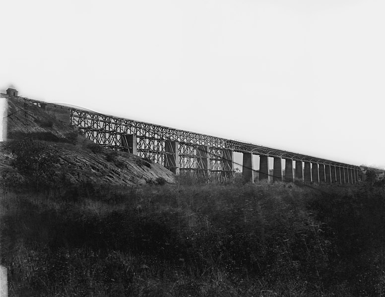
This is an image of a place or building that is listed on the National Register of Historic Places in the United States of America. Its reference number is 8000875. |
| Description |
English: Farmville, Virginia (vicinity). High bridge of the South Side Railroad across the Appomattox. NOTE: Title from Civil War caption books. Caption from negative sleeve: High Bridge across Appomattox River, south side railroad. Farmvill, Va., (vicinity) April 1865. Forms part of Civil War glass negative collection of the Library of Congress. No known restrictions on publication. |
||||||||||||||||||||||||||
| Date | Taken in April 1865 | ||||||||||||||||||||||||||
| Source |
https://www.loc.gov/pictures/resource/cwpb.03733/
|
||||||||||||||||||||||||||
| Author |
|
||||||||||||||||||||||||||
| Permission (Reusing this file) |
No known restrictions on publication. | ||||||||||||||||||||||||||


| Object location | | View this and other nearby images on: OpenStreetMap |
|---|
Transwiki information
Previously uploaded by Hlj to en.wikipedia on 2006-08-23. Transferred from en.wikipedia to Commons. Image cropped by Hal Jespersen. Transwiki approved by: w:en:User:Multichill
Image description page history
| link | date/time | username | edit summary |
|---|---|---|---|
| [1] | 11:06, 22 February 2008 | w:en:User:Multichill | |
| [2] | 12:16, 12 September 2007 | w:en:User:Parsecboy | |
| [3] | 17:14, 3 May 2007 | w:en:User:165.139.9.56 | |
| [4] | 23:21, 23 August 2006 | w:en:User:Hlj | (Image cropped by Hal Jespersen. TITLE: Farmville, Virginia (vicinity). High bridge of the South Side Railroad across the Appomattox CALL NUMBER: LC-B817- 7179[P&P] REPRODUCTION NUMBER: LC-DIG-cwpb-03733 (digital file from original neg.) No known res) |
![[1]](https://en.wikipedia.org/w/index.php?title=Image:High_Bridge_Farmville_Virginia.jpg&redirect=no&oldid=193248333)
![[2]](https://en.wikipedia.org/w/index.php?title=Image:High_Bridge_Farmville_Virginia.jpg&redirect=no&oldid=157362212)
![[3]](https://en.wikipedia.org/w/index.php?title=Image:High_Bridge_Farmville_Virginia.jpg&redirect=no&oldid=127997968)
![[4]](https://en.wikipedia.org/w/index.php?title=Image:High_Bridge_Farmville_Virginia.jpg&redirect=no&oldid=71483915)
Original upload log
| date/time | username | resolution | size | edit summary |
|---|---|---|---|---|
| 23:21, 23 August 2006 | w:en:User:Hlj | 904×629 | 115 KB | Image cropped by Hal Jespersen. TITLE: Farmville, Virginia (vicinity). High bridge of the South Side Railroad across the Appomattox CALL NUMBER: LC-B817- 7179[P&P] REPRODUCTION NUMBER: LC-DIG-cwpb-03733 (digital file from original neg.) No known res |
Licensing
This work is in the public domain in the United States because it was published (or registered with the U.S. Copyright Office) before January 1, 1929.
Public domain works must be out of copyright in both the United States and in the source country of the work in order to be hosted on the Commons. If the work is not a U.S. work, the file must have an additional copyright tag indicating the copyright status in the source country.
Note: This tag should not be used for sound recordings. |
File history
Click on a date/time to view the file as it appeared at that time.
| Date/Time | Thumbnail | Dimensions | User | Comment | |
|---|---|---|---|---|---|
| current | 23:54, 3 May 2020 | | 6,653 × 5,138 (15.25 MB) | Taterian | higher resolution |
| 18:41, 25 February 2008 |  | 904 × 629 (115 KB) | BetacommandBot | Transwiki approved by: w:en:User:Multichill {{Information |Description={{en|Image cropped by Hal Jespersen. TITLE: Farmville, Virginia (vicinity). High bridge of the South Side Railroad across the Appomattox CALL NUMBER: LC-B817- 7179[P&P] REP |
File usage
The following pages on the English Wikipedia use this file (pages on other projects are not listed):
- Appomattox campaign
- Battle of High Bridge
- Farmville, Virginia
- High Bridge (Appomattox River)
- High Bridge Trail State Park
- List of bridges on the National Register of Historic Places in Virginia
- National Register of Historic Places listings in Cumberland County, Virginia
- National Register of Historic Places listings in Prince Edward County, Virginia
Global file usage
The following other wikis use this file:
- Usage on en.wikivoyage.org
- Usage on es.wikipedia.org
- Usage on ja.wikipedia.org
- Usage on nl.wikipedia.org
- Usage on ru.wikipedia.org
- Usage on sv.wikipedia.org
- Usage on www.wikidata.org