
Size of this preview: 800 × 600 pixels. Other resolutions: 320 × 240 pixels | 640 × 480 pixels | 1,024 × 768 pixels | 1,280 × 960 pixels | 2,560 × 1,919 pixels | 4,362 × 3,270 pixels.
Original file (4,362 × 3,270 pixels, file size: 5.55 MB, MIME type: image/jpeg)
| This is a file from the Wikimedia Commons. Information from its description page there is shown below. Commons is a freely licensed media file repository. You can help. |
Summary
| Title |
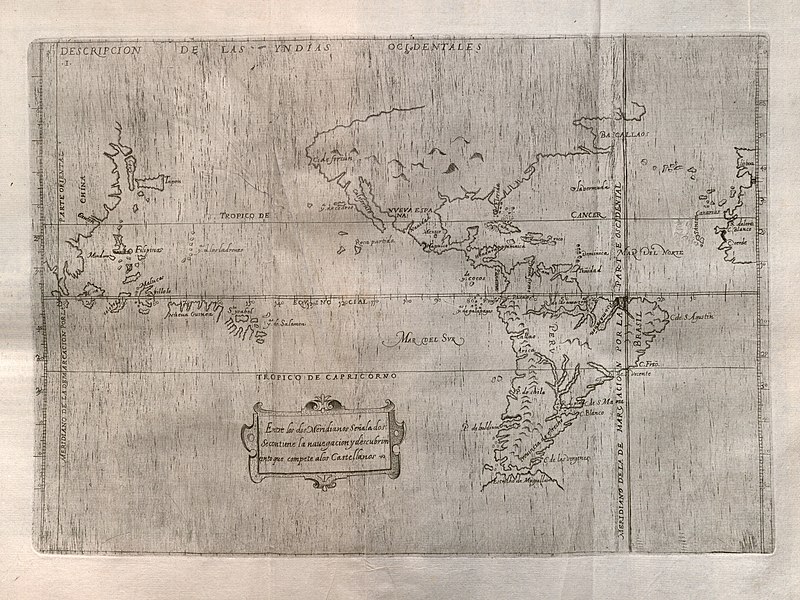
Español: Descripcion de las Yndias Ocidentales |
||||||||||||||||||||||||||
| Description |
English: Spain's official history of the discovery, conquest, and colonization of the Indies at the end of the sixteenth century includes maps of which this is the first, covering the western portions of the Iberian Peninsula and Africa, the Atlantic, both the Americas, the Pacific Ocean, and the eastern portion of Asia. Prominent at right in the map is the meridian line dividing Portuguese and Spanish possessions according to the 1494 Treaty of Tordesillas. The map is largely based upon manuscript charts by Juan Lopez de Velasco, created between ca. 1575-1580. By this time the Spanish had obviously accumulated considerable geographic knowledge along with their extensive claims to a large portion of the world. The outlines of the continents, islands, and various other geographical features are remarkably accurate for their time. |
||||||||||||||||||||||||||
| Date | |||||||||||||||||||||||||||
| Source | UTA Libraries Cartographic Connections: map / text | ||||||||||||||||||||||||||
| Creator |
|
||||||||||||||||||||||||||
| Credit line |
English: The University of Texas at Arlington Libraries Special Collections |
||||||||||||||||||||||||||
| Georeferencing | If inappropriate please set warp_status = skip to hide. | ||||||||||||||||||||||||||
| Bibliographic data | |||||||||||||||||||||||||||
| Publication |
Historia General de los Hechos de los Castellanos en las Islas i Tierra Firme del Mar Oceano |
||||||||||||||||||||||||||
| Author |
|
||||||||||||||||||||||||||
| Volume | 2 | ||||||||||||||||||||||||||
| Place of publication | Madrid | ||||||||||||||||||||||||||
| Publisher | |||||||||||||||||||||||||||
| Archival data | |||||||||||||||||||||||||||
| Collection |
|
||||||||||||||||||||||||||
| Dimensions | height: 22.5 cm (8.8 in); width: 32 cm (12.5 in) | ||||||||||||||||||||||||||
| Medium | engraving on paper | ||||||||||||||||||||||||||
| artwork-references | Burden, Philip D. (1996) The Mapping of North America: A List of Printed Maps 1511-1670, Herts, England: Raleigh Publications, no. 140 , p. 169 | ||||||||||||||||||||||||||

Licensing

|
This file was provided to Wikimedia Commons by the University of Texas at Arlington Libraries as part of a cooperation project. The University of Texas at Arlington Libraries is part of the University of Texas at Arlington, a public research university located in Arlington, Texas.
|
|
The author died in 1626, so this work is in the public domain in its country of origin and other countries and areas where the copyright term is the author's life plus 100 years or fewer. This work is in the public domain in the United States because it was published (or registered with the U.S. Copyright Office) before January 1, 1929. | |
| This file has been identified as being free of known restrictions under copyright law, including all related and neighboring rights. | |
File history
Click on a date/time to view the file as it appeared at that time.
| Date/Time | Thumbnail | Dimensions | User | Comment | |
|---|---|---|---|---|---|
| current | 13:28, 23 May 2019 | | 4,362 × 3,270 (5.55 MB) | Michael Barera | == {{int:filedesc}} == {{Map |title = ''Descripcion de las Yndias Ocidentales'' |description = {{en|Spain's official history of the discovery, conquest, and colonization of the Indies at the end of the sixteenth century includes maps of which this is the first, covering the western portions of the Iberian Peninsula and Africa, the Atlantic, both the Americas, the Pacific Ocean, and the eastern portion of Asia. Prominent at right in the map is the meridian line dividing Por... |
File usage
The following pages on the English Wikipedia use this file (pages on other projects are not listed):
Global file usage
The following other wikis use this file:
- Usage on es.wikipedia.org
- Usage on lv.wikipedia.org