
Size of this preview: 800 × 533 pixels. Other resolutions: 320 × 213 pixels | 640 × 427 pixels | 1,024 × 683 pixels | 1,280 × 853 pixels | 2,160 × 1,440 pixels.
Original file (2,160 × 1,440 pixels, file size: 597 KB, MIME type: image/jpeg)
| This is a file from the Wikimedia Commons. Information from its description page there is shown below. Commons is a freely licensed media file repository. You can help. |
Summary
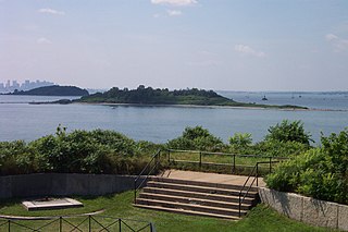
| Description | Gallops Island (center) in Boston Harbor as viewed from Fort Warren on Georges Island. Skyline of downtown Boston to top left, over the tip of Long Island. For more information see the Wikipedia article w:en:Gallops Island. |
| Date | Taken on 14 July 2006, 14:56 |
| Source | Photograph by myself with original filename DCP_4806.JPG. |
| Author | Chris Wood (User:chris_j_wood). |
| Permission (Reusing this file) |
Copyright (c) 2006 Chris Wood. Uploaded by the copyright holder under the terms of the GFDL (see below). |
| Object location | | View this and other nearby images on: OpenStreetMap |
|---|
| Camera location | | View this and other nearby images on: OpenStreetMap |
|---|
Licensing
I, the copyright holder of this work, hereby publish it under the following licenses:
This file is licensed under the Creative Commons Attribution-Share Alike 4.0 International license.
Attribution: Chris Wood
- You are free:
- to share – to copy, distribute and transmit the work
- to remix – to adapt the work
- Under the following conditions:
- attribution – You must give appropriate credit, provide a link to the license, and indicate if changes were made. You may do so in any reasonable manner, but not in any way that suggests the licensor endorses you or your use.
- share alike – If you remix, transform, or build upon the material, you must distribute your contributions under the same or compatible license as the original.
This file is licensed under the Creative Commons Attribution-Share Alike 3.0 Unported license.
Attribution: Chris Wood
- You are free:
- to share – to copy, distribute and transmit the work
- to remix – to adapt the work
- Under the following conditions:
- attribution – You must give appropriate credit, provide a link to the license, and indicate if changes were made. You may do so in any reasonable manner, but not in any way that suggests the licensor endorses you or your use.
- share alike – If you remix, transform, or build upon the material, you must distribute your contributions under the same or compatible license as the original.

|
Permission is granted to copy, distribute and/or modify this document under the terms of the GNU Free Documentation License, Version 1.2 or any later version published by the Free Software Foundation; with no Invariant Sections, no Front-Cover Texts, and no Back-Cover Texts. A copy of the license is included in the section entitled GNU Free Documentation License. |
You may select the license of your choice.
File history
Click on a date/time to view the file as it appeared at that time.
| Date/Time | Thumbnail | Dimensions | User | Comment | |
|---|---|---|---|---|---|
| current | 13:04, 27 August 2006 | | 2,160 × 1,440 (597 KB) | Chris j wood | == Summary == {{Information| |Description = Gallops Island (center) in Boston Harbor as viewed from Fort Warren on Georges Island. Skyline of downtown Boston to top left, over the tip of Long Island. For more information see the Wikipedia article ''[[w:e |
File usage
The following pages on the English Wikipedia use this file (pages on other projects are not listed):
Global file usage
The following other wikis use this file:
- Usage on ceb.wikipedia.org
- Usage on de.wikipedia.org
- Usage on www.wikidata.org