
Size of this preview: 800 × 351 pixels. Other resolutions: 320 × 140 pixels | 640 × 281 pixels | 1,425 × 625 pixels.
Original file (1,425 × 625 pixels, file size: 39 KB, MIME type: image/gif)
| This is a file from the Wikimedia Commons. Information from its description page there is shown below. Commons is a freely licensed media file repository. You can help. |
Summary
| Description |
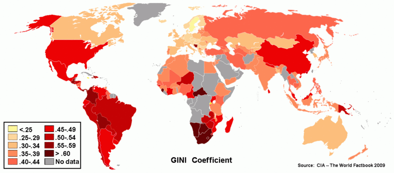
English: Gini-coefficient of national income distribution around the world (using 1989-2009 CIA estimates) |
| Date | |
| Source | https://www.cia.gov/library/publications/the-world-factbook |
| Author | Modified version by U.S. CIA |
| Other versions | File:GINIretouchedcolors.png - with smaller legend box |
Licensing
This image is in the public domain because it contains materials that originally came from the United States Central Intelligence Agency's World Factbook.
|
 |
File history
Click on a date/time to view the file as it appeared at that time.
| Date/Time | Thumbnail | Dimensions | User | Comment | |
|---|---|---|---|---|---|
| current | 05:25, 12 October 2013 | | 1,425 × 625 (39 KB) | TristanPhoenix | U.S. GINI at 47.7 http://www.census.gov/newsroom/releases/archives/income_wealth/cb12-172.html |
| 05:23, 12 October 2013 |  | 1,425 × 625 (39 KB) | TristanPhoenix | Reverted to version as of 04:10, 5 June 2013 | |
| 05:19, 12 October 2013 |  | 1,425 × 625 (39 KB) | TristanPhoenix | U.S. GINI At 47.7 | |
| 13:52, 12 September 2013 |  | 1,425 × 625 (193 KB) | J intela | Correcting chart, giving real US post tax Gini, | |
| 04:10, 5 June 2013 |  | 1,425 × 625 (39 KB) | Leehach | Sorry, wrong one. Same reason applies. See Wikipedia entry on choropleth maps http://en.wikipedia.org/wiki/Choropleth_map | |
| 04:07, 5 June 2013 |  | 1,350 × 625 (32 KB) | Leehach | Fmalan is right. Hue-varying color scheme is appropriate for categorical data (like religion or land cover). Quantitative data should use a sequential scheme which varies intensity and saturation. See Slocum, Thematic Cartography & Geovisualization 3e,... | |
| 12:14, 29 May 2013 |  | 1,350 × 625 (78 KB) | Spencer | fix color for Bosnia, see eng.wiki talk page for the comments | |
| 08:30, 20 May 2013 |  | 1,350 × 625 (78 KB) | Kwamikagami | restore iconic color coding (shade is difficult to distinguish) | |
| 14:22, 18 January 2013 |  | 1,425 × 625 (39 KB) | Fmalan | Changed to colour mapping to a perceptually monotonic map more suitable to data visualization. Changes by user 91.127.95.103 under CC license. | |
| 05:36, 25 November 2012 |  | 1,350 × 625 (32 KB) | Wikid77 | put 1-column legend (was 2); narrowed map 5% to enlarge labels 5.3% at same width. |
File usage
The following pages on the English Wikipedia use this file (pages on other projects are not listed):
Global file usage
The following other wikis use this file:
- Usage on ca.wikipedia.org
- Usage on pl.wikipedia.org