
Size of this preview: 800 × 504 pixels. Other resolutions: 320 × 201 pixels | 640 × 403 pixels | 1,024 × 645 pixels | 1,280 × 806 pixels | 2,560 × 1,612 pixels | 10,800 × 6,800 pixels.
Original file (10,800 × 6,800 pixels, file size: 18.06 MB, MIME type: image/jpeg)
| This is a file from the Wikimedia Commons. Information from its description page there is shown below. Commons is a freely licensed media file repository. You can help. |
| Warning | The original file is very high-resolution. It might not load properly or could cause your browser to freeze when opened at full size. |
|---|
Summary
| Description |
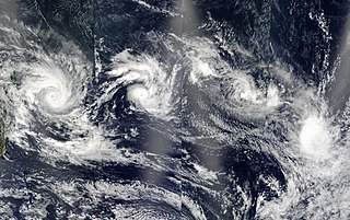
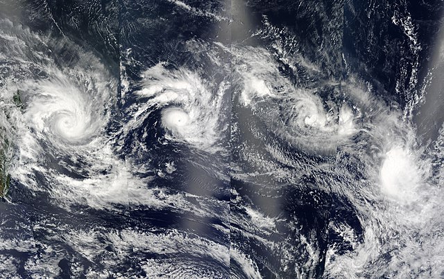
A train of four tropical cyclones is still lined up in the southern Indian Ocean east of Madagascar (left) on Feb. 12, 2003. This true-color image of the storms was made from observations collected by alternating passes of the Aqua and Terra satellites. The cyclones pictured are (east to west) Gerry, Hape, 18S (Pre-Cyclone Isha), and Fiona. Each of the storms appears to have followed the track predicted for it at the time of the first image in the series, captured on Feb, 11. In this image, the storms are generally east or southeast of where there were previously. Terra passed over this area in the morning, moving east to west, and contributing the second and fourth chunks of the image (from right to left). Aqua passed over in the afternoon, also moving east to west, contributing the first and third chunks. |
|||||
| Date | ||||||
| Source | http://visibleearth.nasa.gov/view_rec.php?id=4941 | |||||
| Author | Jeff Schmaltz, MODIS Rapid Response Team, NASA/GSFC | |||||
| Permission (Reusing this file) |
|
|||||
| Other versions |

_12_feb_2003_0825Z.jpg)

.jpg)
.jpg&action=edit&redlink=1)
.jpg)
File history
Click on a date/time to view the file as it appeared at that time.
| Date/Time | Thumbnail | Dimensions | User | Comment | |
|---|---|---|---|---|---|
| current | 19:16, 6 December 2006 | | 10,800 × 6,800 (18.06 MB) | Good kitty | Reverted to earlier revision |
| 19:16, 6 December 2006 |  | 10,800 × 6,800 (18.06 MB) | Good kitty | Reverted to earlier revision | |
| 16:41, 6 December 2006 |  | 1,111 × 700 (201 KB) | Yuval CT | resisized to 1111x700 | |
| 15:06, 1 September 2006 |  | 10,800 × 6,800 (18.06 MB) | Good kitty | ||
| 01:07, 3 January 2006 |  | 600 × 315 (83 KB) | Hurricanehink | From https://metoc.npmoc.navy.mil/jtwc/atcr/2003atcr/, this MODIS true color satellite image shows Cyclone Gerry, Cyclone Hape, Tropical Storm Isha, and Tropical Storm Fiona on February 12, 2003. {{PD-USGov-NOAA}} {{NOAA logo}} [[Category:Southern hemi |
File usage
The following pages on the English Wikipedia use this file (pages on other projects are not listed):
- 2002–03 South-West Indian Ocean cyclone season
- Tropical cyclones in 2003
- Weather of 2003
- Wikipedia:Featured and good topic candidates/2002–03 South-West Indian Ocean cyclone season/archive1
- Wikipedia:Featured and good topic candidates/Featured log/July 2013
- Wikipedia:Featured and good topic candidates/Good log/July 2013
- Wikipedia:Featured topics/2002–03 South-West Indian Ocean cyclone season
- Wikipedia:Good topics
- Portal:Tropical cyclones/Anniversaries/February
- Portal:Tropical cyclones/Anniversaries/February/12
- Portal:Tropical cyclones/Selected image
- Portal:Tropical cyclones/Selected image/15
.jpg)