Fort_Heath_1961.png (325 × 306 pixels, file size: 46 KB, MIME type: image/png)
| Description |
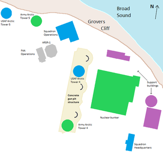
Geometrical map of military structures and landforms on coastal headland. |
|---|---|
| Source |
recreated from copyrighted map |
| Article | |
| Portion used |
Outlines of structures and landforms are the only portions from the source (shading was added during re-creation for clarity) |
| Low resolution? |
Yes (625x589 pixels) |
| Purpose of use |
The image illustrates the location of radar station structures relative to a former gun battery foundation and a physiographic headland. |
| Replaceable? |
Free-use maps do not show position of Cold War structures. Structures no longer exist, so all images of structures (e.g., of their outlines) must be from previous images. |
| Other information |
The use of the outlines will not affect the value of the source or limit copyright holder's rights. |
| Fair useFair use of copyrighted material in the context of Fort Heath radar station//en.wikipedia.org/wiki/File:Fort_Heath_1961.pngtrue | |
 | This work is copyrighted (or assumed to be copyrighted) and unlicensed. It does not fall into one of the blanket acceptable non-free content categories listed at Wikipedia:Non-free content § Images or Wikipedia:Non-free content § Audio clips, and it is not covered by a more specific non-free content license listed at Category:Wikipedia non-free file copyright templates. However, it is believed that the use of this work:
qualifies as fair use under United States copyright law. Any other uses of this image, on Wikipedia or elsewhere, may be copyright infringement. See Wikipedia:Non-free content and Wikipedia:Copyrights. |
File history
Click on a date/time to view the file as it appeared at that time.
| Date/Time | Thumbnail | Dimensions | User | Comment | |
|---|---|---|---|---|---|
| current | 00:14, 10 April 2017 | | 325 × 306 (46 KB) | DatBot (talk | contribs) | Reduce size of non-free image (BOT - disable) |
| 17:15, 7 May 2013 | No thumbnail | 625 × 589 (23 KB) | 30 SW (talk | contribs) | author=self license=may be viewed at this website, and may be cited by other websites |
You cannot overwrite this file.