
Size of this preview: 800 × 520 pixels. Other resolutions: 320 × 208 pixels | 640 × 416 pixels | 1,024 × 665 pixels | 1,513 × 983 pixels.
Original file (1,513 × 983 pixels, file size: 58 KB, MIME type: image/png)
| This is a file from the Wikimedia Commons. Information from its description page there is shown below. Commons is a freely licensed media file repository. You can help. |
Summary
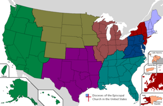
| Description | Map of the provinces of the Episcopal Church in the United States of America |
| Date | |
| Source | User-made by w:User:Aef711 |
| Author | w:User:Aef711 |
Licensing
Aef711 at the English-language Wikipedia, the copyright holder of this work, hereby publishes it under the following license:

|
Permission is granted to copy, distribute and/or modify this document under the terms of the GNU Free Documentation License, Version 1.2 or any later version published by the Free Software Foundation; with no Invariant Sections, no Front-Cover Texts, and no Back-Cover Texts. A copy of the license is included in the section entitled GNU Free Documentation License. |
| This file is licensed under the Creative Commons Attribution-Share Alike 3.0 Unported license. | ||
| Attribution: Aef711 | ||
| ||
| This licensing tag was added to this file as part of the GFDL licensing update. |
File history from English Wikipedia
- 07:21, 24 April 2007 | User:Aef711 (Talk | contribs) | 1513×983 85 KB | created myself, based on map of US counties already on wikipedia.
21:25, 10 May 2007 Cydebot (Talk | contribs | block) m (104 bytes) (Robot - Fixing GFDL tags project-wide per Wikipedia:GFDL standardization.) (rollback | undo)
07:21, 24 April 2007 Aef711 (Talk | contribs | block) (119 bytes) (created myself, based on map of US counties already on wikipedia.)
File history
Click on a date/time to view the file as it appeared at that time.
| Date/Time | Thumbnail | Dimensions | User | Comment | |
|---|---|---|---|---|---|
| current | 05:13, 26 December 2023 | | 1,513 × 983 (58 KB) | JsfasdF252 | Remove compression artifacts |
| 16:07, 30 November 2022 |  | 1,200 × 780 (744 KB) | Dclemens1971 | Updated to reflect merger of North Texas into Diocese of Texas | |
| 05:14, 10 April 2015 |  | 1,513 × 983 (80 KB) | Schetm | Updating map to reflect dissolution of the Diocese of Quincy. | |
| 18:10, 25 September 2007 |  | 1,513 × 983 (85 KB) | Mahagaja | {{Information |Description=Map of the provinces of the Episcopal Church in the United States of America |Source=User-made by w:User:Aef711 |Date=2007-04-27 |Author=w:User:Aef711 }} ==Licensing== {{GFDL-user-w|en|English Wikipedia|Aef711}} |
File usage
The following pages on the English Wikipedia use this file (pages on other projects are not listed):
- Ecclesiastical provinces and dioceses of the Episcopal Church
- List of Episcopal bishops of the United States
- List of the Episcopal cathedrals of the United States
- Province 1 of the Episcopal Church
- Province 2 of the Episcopal Church
- Province 3 of the Episcopal Church
- Province 4 of the Episcopal Church
- Province 5 of the Episcopal Church
- Province 6 of the Episcopal Church
- Province 7 of the Episcopal Church
- Province 8 of the Episcopal Church
- Province 9 of the Episcopal Church
- Wikipedia:Reference desk/Archives/Humanities/2011 March 5
Global file usage
The following other wikis use this file:
- Usage on de.wikipedia.org
- Usage on it.wikipedia.org
- Usage on ko.wikipedia.org
- Usage on nl.wikipedia.org
- Usage on ru.wikipedia.org
- Usage on uk.wikipedia.org