
Size of this preview: 800 × 461 pixels. Other resolutions: 320 × 184 pixels | 640 × 369 pixels | 1,024 × 590 pixels | 1,280 × 738 pixels | 3,541 × 2,041 pixels.
Original file (3,541 × 2,041 pixels, file size: 1.09 MB, MIME type: image/jpeg)
| This is a file from the Wikimedia Commons. Information from its description page there is shown below. Commons is a freely licensed media file repository. You can help. |
Summary
| Description |
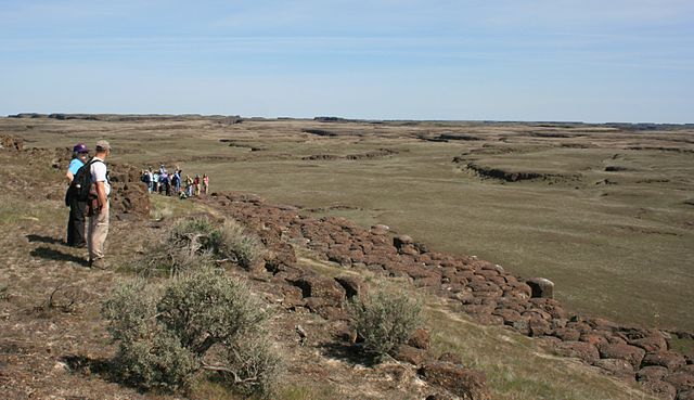
English: w:Drumheller Channels National Natural Landmark showcases the Drumheller Channels, which are the most significant example in the w:Columbia Plateau of basalt butte-and-basin w:channeled scablands. This w:National Natural Landmark is an extensively eroded landscape, located in south central w:Washington state characterized by hundreds of isolated, steep-sided hills (buttes) surrounded by a braided network of numerous channels, all but one of which are currently dry. It is a classic example of the tremendous erosive powers of extremely large floods such as those that reformed the Columbia Plateau volcanic terrain during the late w:Pleistocene glacial w:Missoula Floods. |
| Date | Taken on 18 April 2009 |
| Source | Own work |
| Author | Williamborg (talk · contribs) |
All rights released.
Licensing
| I, the copyright holder of this work, release this work into the public domain. This applies worldwide. In some countries this may not be legally possible; if so: I grant anyone the right to use this work for any purpose, without any conditions, unless such conditions are required by law. |
File history
Click on a date/time to view the file as it appeared at that time.
| Date/Time | Thumbnail | Dimensions | User | Comment | |
|---|---|---|---|---|---|
| current | 00:47, 19 April 2009 | | 3,541 × 2,041 (1.09 MB) | Williamborg | {{Information |Description={{en|1=w:Drumheller Channels National Natural Landmark showcases the '''Drumheller Channels''', which are the most significant example in the w:Columbia Plateau of basalt butte-and-basin w:channeled scablands. This [ |
File usage
The following pages on the English Wikipedia use this file (pages on other projects are not listed):
Global file usage
The following other wikis use this file:
- Usage on ar.wikipedia.org
- Usage on cs.wikipedia.org
- Usage on de.wikipedia.org
- Usage on www.wikidata.org