
Size of this preview: 800 × 600 pixels. Other resolutions: 320 × 240 pixels | 640 × 480 pixels | 1,024 × 768 pixels | 1,280 × 960 pixels | 2,272 × 1,704 pixels.
Original file (2,272 × 1,704 pixels, file size: 1.52 MB, MIME type: image/jpeg)
| This is a file from the Wikimedia Commons. Information from its description page there is shown below. Commons is a freely licensed media file repository. You can help. |
| Camera location | | View this and other nearby images on: OpenStreetMap |
|---|
| Description |
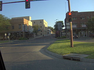
English: Buildings along First Avenue in downtown Dodge City, Kansas, United States, as viewed from its intersection with Wyatt Earp Boulevard (U.S. Routes 50/400). This part of downtown is within the boundaries of the Dodge City Downtown Historic District, a historic district that is listed on the National Register of Historic Places.
|
||
| Date | Taken on 22 July 2006 | ||
| Source | Own work | ||
| Author | Nyttend | ||
| Permission (Reusing this file) |
|
File history
Click on a date/time to view the file as it appeared at that time.
| Date/Time | Thumbnail | Dimensions | User | Comment | |
|---|---|---|---|---|---|
| current | 22:30, 14 November 2009 | | 2,272 × 1,704 (1.52 MB) | Nyttend | {{Location|37|45|9.2|N|100|1|5.25|W}} {{Information |Description={{en|Buildings along First Avenue in downtown {{w|Dodge City, Kansas|Dodge City}}, {{w|Kansas}}, {{w|United States}}, as viewed from its intersection with Wyatt Earp Boulevard (U.S. Routes { |
File usage
The following pages on the English Wikipedia use this file (pages on other projects are not listed):
Global file usage
The following other wikis use this file:
- Usage on de.wikipedia.org
- Usage on ko.wikipedia.org
- Usage on tl.wikipedia.org
- Usage on www.wikidata.org