
Size of this preview: 600 × 600 pixels. Other resolutions: 240 × 240 pixels | 480 × 480 pixels | 768 × 768 pixels | 1,024 × 1,024 pixels | 1,620 × 1,620 pixels.
Original file (1,620 × 1,620 pixels, file size: 2.27 MB, MIME type: image/jpeg)
| This is a file from the Wikimedia Commons. Information from its description page there is shown below. Commons is a freely licensed media file repository. You can help. |
Summary
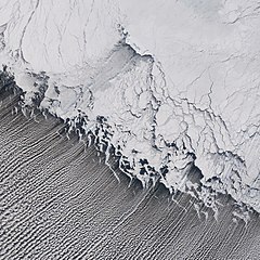
| Description | Satellite image of w:cloud streets in the Bering Sea. w:St. Matthew Island is visible in the upper portion, its mountains casting shadows to the southwest. |
| Date | |
| Source | http://earthobservatory.nasa.gov/Newsroom/NewImages/images.php3?img_id=17171 |
| Author | Jesse Allen, NASA Earth Observatory, using data obtained from the Goddard Earth Sciences DAAC. |
| Permission (Reusing this file) |
US government, public domain |
Licensing
| This file is in the public domain in the United States because it was solely created by NASA. NASA copyright policy states that "NASA material is not protected by copyright unless noted". (See Template:PD-USGov, NASA copyright policy page or JPL Image Use Policy.) | ||
 |
Warnings:
|
File history
Click on a date/time to view the file as it appeared at that time.
| Date/Time | Thumbnail | Dimensions | User | Comment | |
|---|---|---|---|---|---|
| current | 20:12, 28 April 2006 | | 1,620 × 1,620 (2.27 MB) | Holly Cheng | {{Information | Description=Satellite image of w:cloud streets in the Bering Sea. w:St. Matthew Island is visible in the upper portion, its mountains casting shadows to the southwest. | Source=http://earthobservatory.nasa.gov/Newsroom/NewImages/im |
File usage
The following pages on the English Wikipedia use this file (pages on other projects are not listed):
Global file usage
The following other wikis use this file:
- Usage on fr.wikipedia.org
- Usage on it.wikipedia.org
- Usage on lmo.wikipedia.org
- Usage on nl.wikipedia.org
- Usage on sv.wikipedia.org