
Size of this PNG preview of this SVG file: 705 × 599 pixels. Other resolutions: 282 × 240 pixels | 565 × 480 pixels | 904 × 768 pixels | 1,205 × 1,024 pixels | 2,409 × 2,048 pixels | 1,000 × 850 pixels.
Original file (SVG file, nominally 1,000 × 850 pixels, file size: 168 KB)
| This is a file from the Wikimedia Commons. Information from its description page there is shown below. Commons is a freely licensed media file repository. You can help. |
Summary
| Description |
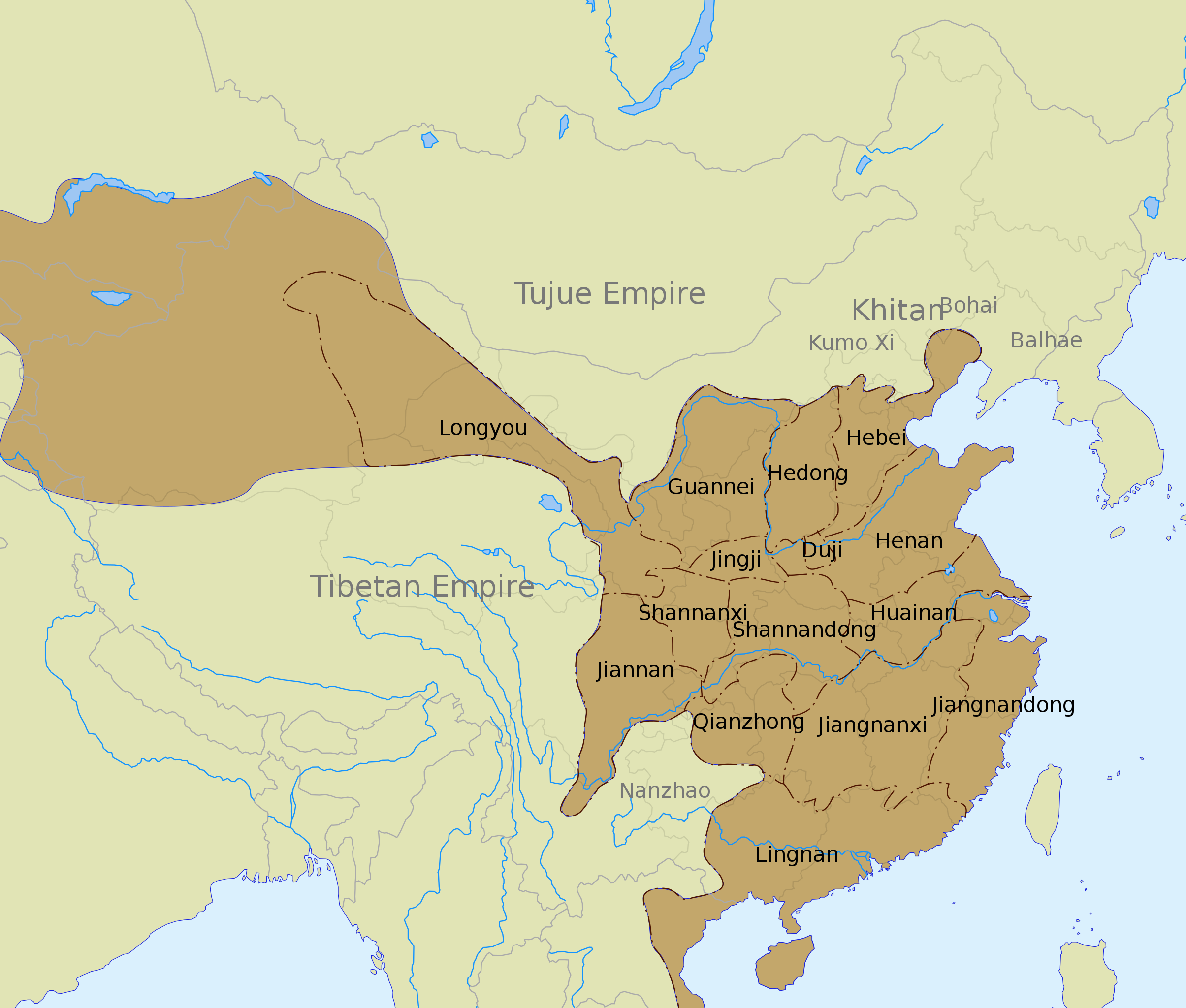
English: The Tang dynasty territory and inspection circuits (道 dào) in 742, according to the Cambridge History of China. |
| Date | |
| Source |
See also:
|
| Author | Yug |
| Other versions |
Derivative works of this file: |
| SVG development |
Licensing
I, the copyright holder of this work, hereby publish it under the following license:
This file is licensed under the Creative Commons Attribution-Share Alike 3.0 Unported license.
- You are free:
- to share – to copy, distribute and transmit the work
- to remix – to adapt the work
- Under the following conditions:
- attribution – You must give appropriate credit, provide a link to the license, and indicate if changes were made. You may do so in any reasonable manner, but not in any way that suggests the licensor endorses you or your use.
- share alike – If you remix, transform, or build upon the material, you must distribute your contributions under the same or compatible license as the original.
File history
Click on a date/time to view the file as it appeared at that time.
| Date/Time | Thumbnail | Dimensions | User | Comment | |
|---|---|---|---|---|---|
| current | 01:45, 12 March 2020 | | 1,000 × 850 (168 KB) | Jonteemil | Fake SVG Reverted to version as of 17:36, 16 December 2012 (UTC) |
| 06:10, 14 January 2019 |  | 1,000 × 850 (278 KB) | 复旦大学张超 | Bohai and Balhae are the same | |
| 17:36, 16 December 2012 |  | 1,000 × 850 (168 KB) | Kanguole | Revise western extent of civil administration per Cambridge History | |
| 04:40, 30 May 2008 |  | 1,000 × 850 (221 KB) | Yug | Correction for the eastern area, according to a newly find sources. | |
| 05:04, 29 May 2008 |  | 1,000 × 850 (221 KB) | Yug | ||
| 18:56, 28 May 2008 |  | 1,000 × 850 (218 KB) | Yug | {{Information |Description={{en|1=The Tang dynasty territory and provinces in 742, according to the Cambridge History of China.<br />NB: The Western area was not depict by my source, accordingly, this area (Longyou province, 隴右) is show by a blur area |
File usage
The following pages on the English Wikipedia use this file (pages on other projects are not listed):
- Administration of territory in dynastic China
- Administrative divisions of the Tang dynasty
- An Lushan
- Circuit (administrative division)
- Emperor Xuanzong of Tang
- Han Chinese
- History of China
- History of the Khitans
- Jiangnan Circuit
- Jiangnanxi Circuit
- Tang dynasty
- Talk:Tang dynasty
- User:Falcaorib
- User talk:PericlesofAthens/Archive 5
- Wikipedia:Graphics Lab/Images to improve/Archive/Jul 2008
Global file usage
The following other wikis use this file:
- Usage on azb.wikipedia.org
- Usage on bo.wikipedia.org
- Usage on ca.wikipedia.org
- Usage on ce.wikipedia.org
- Usage on de.wikipedia.org
- Usage on fa.wikipedia.org
- Usage on fr.wikipedia.org
- Usage on hak.wikipedia.org
- Usage on id.wikipedia.org
- Usage on lt.wikipedia.org
- Usage on nl.wikipedia.org
- Usage on no.wikipedia.org
- Usage on ru.wikipedia.org
- Usage on tr.wikipedia.org
- Usage on uk.wikipedia.org
- Usage on uz.wikipedia.org
- Usage on vi.wikipedia.org
- Usage on www.wikidata.org