No higher resolution available.
Chad_Varah_House_-_geograph.org.uk_-_126505.jpg (640 × 427 pixels, file size: 143 KB, MIME type: image/jpeg)
| This is a file from the Wikimedia Commons. Information from its description page there is shown below. Commons is a freely licensed media file repository. You can help. |
Summary
| Description |
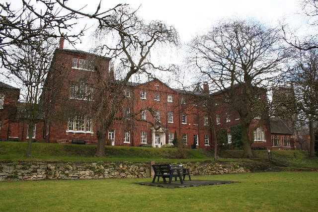
English: Chad Varah House. Named after Chad Varah, founder of the Samaritans who studied here when it was a Theological College. The terracing is reputedly part of the Roman terracing, there were two medieval churches on this site at one time and later the site of the Hare and Hounds Inn, later the Fighting Cocks Inn which was demolished to make way for this building. It started life as the County Hospital by John Carr in 1776 until superseded by the new County Hospital in 1878 and was known as the Bishop's Hostel until renamed in the late 20th century. It is now part of the University of Lincoln Cathedral campus, home to Conservation & Restoration and History of Art & Design. |
| Date | |
| Source | From geograph.org.uk |
| Author | Richard Croft |
| Attribution (required by the license) | Richard Croft / Chad Varah House / |
| Object location | | View this and other nearby images on: OpenStreetMap |
|---|
_&language=en)
Licensing

|
This image was taken from the Geograph project collection. See this photograph's page on the Geograph website for the photographer's contact details. The copyright on this image is owned by Richard Croft and is licensed for reuse under the Creative Commons Attribution-ShareAlike 2.0 license.
|
This file is licensed under the Creative Commons Attribution-Share Alike 2.0 Generic license.
Attribution: Richard Croft
- You are free:
- to share – to copy, distribute and transmit the work
- to remix – to adapt the work
- Under the following conditions:
- attribution – You must give appropriate credit, provide a link to the license, and indicate if changes were made. You may do so in any reasonable manner, but not in any way that suggests the licensor endorses you or your use.
- share alike – If you remix, transform, or build upon the material, you must distribute your contributions under the same or compatible license as the original.
File history
Click on a date/time to view the file as it appeared at that time.
| Date/Time | Thumbnail | Dimensions | User | Comment | |
|---|---|---|---|---|---|
| current | 02:36, 31 January 2010 | | 640 × 427 (143 KB) | GeographBot | == {{int:filedesc}} == {{Information |description={{en|1=Chad Varah House. Named after Chad Varah, founder of the Samaritans who studied here when it was a Theological College. The terracing is reputedly part of the Roman terracing, there were two medieva |
File usage
The following pages on the English Wikipedia use this file (pages on other projects are not listed):
Global file usage
The following other wikis use this file:
- Usage on www.wikidata.org