File:Carte d un voyage fait dans la Belle Riviere en la Nouvelle France M.DCC XLIX. Par le Reverend Pere Bonnecamps Jesuite Mathematicien.jpg

Size of this preview: 713 × 599 pixels. Other resolutions: 286 × 240 pixels | 571 × 480 pixels | 960 × 807 pixels.
Original file (960 × 807 pixels, file size: 241 KB, MIME type: image/jpeg)
| This is a file from the Wikimedia Commons. Information from its description page there is shown below. Commons is a freely licensed media file repository. You can help. |
Summary
| Description |
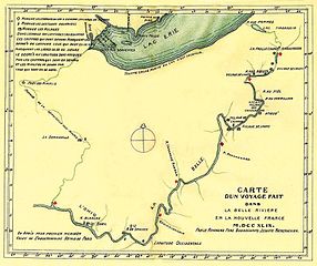
English: Father Bonnecamp's 1749 map showing where lead plates were buried.
Français : Carte d'un voyage fait dans la Belle Rivière en la Nouvelle France M.DCC XLIX. Par le Révérend Père Bonnécamps Jésuite Mathématicien |
| Date | |
| Source | facebook.com |
| Author | Joseph-Pierre de Bonnécamps |
Licensing
|
This work is in the public domain in its country of origin and other countries and areas where the copyright term is the author's life plus 70 years or fewer. This work is in the public domain in the United States because it was published (or registered with the U.S. Copyright Office) before January 1, 1929. | |
| This file has been identified as being free of known restrictions under copyright law, including all related and neighboring rights. | |
| Annotations | This image is annotated: View the annotations at Commons |
File history
Click on a date/time to view the file as it appeared at that time.
| Date/Time | Thumbnail | Dimensions | User | Comment | |
|---|---|---|---|---|---|
| current | 22:26, 28 July 2016 | | 960 × 807 (241 KB) | Jeangagnon | User created page with UploadWizard |
File usage
The following pages on the English Wikipedia use this file (pages on other projects are not listed):
Global file usage
The following other wikis use this file:
- Usage on fr.wikipedia.org
- Usage on ru.wikipedia.org