
Size of this preview: 787 × 599 pixels. Other resolutions: 315 × 240 pixels | 630 × 480 pixels | 1,009 × 768 pixels | 1,120 × 853 pixels.
Original file (1,120 × 853 pixels, file size: 92 KB, MIME type: image/png)
| This is a file from the Wikimedia Commons. Information from its description page there is shown below. Commons is a freely licensed media file repository. You can help. |
Summary
| Description |
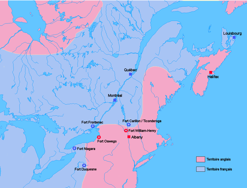
Français : Carte générale des positions anglaises et françaises en Amériques du Nord juste avant le début de la guerre de Sept ans.
English: Map of English and French positions in North America just before the beginning of the Seven Years' War. |
| Date | 18 October 2006 (original upload date) |
| Source | No machine-readable source provided. Own work assumed (based on copyright claims). |
| Author | No machine-readable author provided. Wordelle assumed (based on copyright claims). |
| Other versions | Derivative works of this file: Carte Guerre de 7 ans Amérique du nord2.PNG |
Licensing
| I, the copyright holder of this work, release this work into the public domain. This applies worldwide. In some countries this may not be legally possible; if so: I grant anyone the right to use this work for any purpose, without any conditions, unless such conditions are required by law. |
File history
Click on a date/time to view the file as it appeared at that time.
| Date/Time | Thumbnail | Dimensions | User | Comment | |
|---|---|---|---|---|---|
| current | 09:15, 18 October 2006 | | 1,120 × 853 (92 KB) | Wordelle | Carte générale des positions anglaises et françaises en Amériques du Nord juste avant le début de la guerre de Sept ans. |
File usage
The following pages on the English Wikipedia use this file (pages on other projects are not listed):
Global file usage
The following other wikis use this file:
- Usage on af.wikipedia.org
- Usage on ar.wikipedia.org
- Usage on ca.wikipedia.org
- Usage on da.wikipedia.org
- Usage on de.wikipedia.org
- Usage on eo.wikipedia.org
- Usage on es.wikipedia.org
- Usage on eu.wikipedia.org
- Usage on fr.wikipedia.org
- Usage on gl.wikipedia.org
- Usage on he.wikipedia.org
- Usage on it.wikipedia.org
- Usage on ja.wikipedia.org
- Usage on ko.wikipedia.org
- Usage on ml.wikipedia.org
- Usage on no.wikipedia.org
- Usage on ro.wikipedia.org
- Usage on sl.wikipedia.org
- Usage on sv.wikipedia.org
- Usage on sw.wikipedia.org
- Usage on tr.wikipedia.org