
Size of this preview: 800 × 533 pixels. Other resolutions: 320 × 213 pixels | 640 × 427 pixels | 1,024 × 683 pixels | 1,280 × 853 pixels | 2,560 × 1,707 pixels | 3,456 × 2,304 pixels.
Original file (3,456 × 2,304 pixels, file size: 3.38 MB, MIME type: image/jpeg)
| This is a file from the Wikimedia Commons. Information from its description page there is shown below. Commons is a freely licensed media file repository. You can help. |
Summary
| Description |
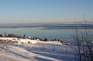
English: Capitale-Nationale, MRC Charlevoix-Est, La Malbaie (City), Cap-à-l'Aigle (Village Municipality before 1999), Route No. 138 East, part of the village, Upper St. Lawrence Estuary, ice drifting, on the horizon, South Shore, 2:55 PM Saturday, January 23, 2010
Français : Capitale-Nationale, MRC Charlevoix-Est, La Malbaie (Ville), Cap-à-l'Aigle (Municipalité de village avant 1999), de la route nº 138 Est, une partie du village, estuaire moyen du Saint-Laurent, les glaces en dérive, à l'horizon, la rive sud, 14:55 le samedi 23 janvier 2010 |
| Date | |
| Source | Own work |
| Author | Nichole Ouellette/ouellette001.com |
Estuaire du fleuve Saint-Laurent
Parc maritime, Saint-Laurent-de-l'Île-d'Orléans
- Section estuarienne du Saint-Laurent
- Section maritime du Saint-Laurent 1
- Section maritime du Saint-Laurent 2
- Portion du fleuve sous puissance des marées d’eau douce
Licensing
I, the copyright holder of this work, hereby publish it under the following license:
This file is licensed under the Creative Commons Attribution 4.0 International license.
- You are free:
- to share – to copy, distribute and transmit the work
- to remix – to adapt the work
- Under the following conditions:
- attribution – You must give appropriate credit, provide a link to the license, and indicate if changes were made. You may do so in any reasonable manner, but not in any way that suggests the licensor endorses you or your use.
File history
Click on a date/time to view the file as it appeared at that time.
| Date/Time | Thumbnail | Dimensions | User | Comment | |
|---|---|---|---|---|---|
| current | 02:06, 24 April 2024 | | 3,456 × 2,304 (3.38 MB) | Nichole Ouellette | Uploaded own work with UploadWizard |
File usage
The following pages on the English Wikipedia use this file (pages on other projects are not listed):