File:Canada swine flu map.svg

Original file(SVG file, nominally 978 × 950 pixels, file size: 76 KB)

This file has been superseded by H1N1 Canada map.svg. It is recommended to use the other file. Please note that deleting superseded images requires consent.

Reason to use the other file: "Morts au Yukon, à Terre-Neuve-Labrador et en Nouvelle-Écosse. Mettre les territoires en noir, mais je sais pas comment. Deaths in Yukon, Newfoundland-Labrador and Nova Scotia. Territories in black, but I don't know how. (Sorry for the translation)"
new file

Summary

Description
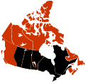
English: Map showing provinces and territories reporting 2009 swine flu (H1N1) cases in Canada.
 
Confirmed death and infections
 
Confirmed infections
 
Unconfirmed infections
The map can be edited very rapidly because it is a current event which is changing hour by hour.

Français : Carte montrant les provinces et territoires selon les cas de la grippe A (H1N1) de 2009 au Canada.
 
Morts confirmées
 
Infections confirmées
 
Infections non confirmées
Cette carte peut évoluer très rapidement, car il s'agit d'un événement en cours.

Português: Mapa das províncias e territórios afectados pela pandemia de gripe de 2009 no Canadá.
 
Mortes confirmadas
 
Casos confirmados
 
Casos suspeitos
Este mapa pode mudar muito rapidamente, pois trata-se de um acontecimento actual.

SVG development
InfoField
 
The SVG code is valid.
 
This map was created with Adobe Illustrator.
Date
Source Adapted from Canada_blank_map.svg created by Lokal_Profil
Author Hyandrew
Permission
(Reusing this file)
w:en:Creative Commons
attribution share alike
This file is licensed under the Creative Commons Attribution-Share Alike 3.0 Unported license.
You are free:
  • to share – to copy, distribute and transmit the work
  • to remix – to adapt the work
Under the following conditions:
  • attribution – You must give appropriate credit, provide a link to the license, and indicate if changes were made. You may do so in any reasonable manner, but not in any way that suggests the licensor endorses you or your use.
  • share alike – If you remix, transform, or build upon the material, you must distribute your contributions under the same or compatible license as the original.

Captions

Add a one-line explanation of what this file represents

Items portrayed in this file

depicts

27 April 2009

image/svg+xml

0d3743244616748cdc21718ccfb8f042467513f4

78,118 byte

950 pixel

978 pixel

File history

Click on a date/time to view the file as it appeared at that time.

(newest | oldest) View (newer 10 | ) (10 | 20 | 50 | 100 | 250 | 500)
Date/TimeThumbnailDimensionsUserComment
current00:17, 4 August 2009Thumbnail for version as of 00:17, 4 August 2009978 × 950 (76 KB)FonadierFixed colors
15:15, 2 August 2009Thumbnail for version as of 15:15, 2 August 2009978 × 950 (64 KB)SpaceFlight89Derivative of previous version; update contributed by 76.66.202.123
09:18, 18 July 2009Thumbnail for version as of 09:18, 18 July 2009978 × 950 (64 KB)Graeme Bartlett 76.66.192.91 bugfix - Akimiski Island -- derived from File:Canada swine flu map.svg & File:H1N1 Canada human swine flu - deaths - CSS map.svg
22:48, 17 July 2009Thumbnail for version as of 22:48, 17 July 2009978 × 950 (71 KB)AxGRm layering
06:23, 17 July 2009Thumbnail for version as of 06:23, 17 July 2009978 × 950 (76 KB)Vrysxyupdated
05:46, 15 July 2009Thumbnail for version as of 05:46, 15 July 2009978 × 950 (76 KB)VrysxyUpdating
12:55, 11 July 2009Thumbnail for version as of 12:55, 11 July 2009978 × 950 (64 KB)Graeme Bartlett contributed by 70.29.208.69 – derived from File:Canada swine flu map.svg - fix Anticosti Island Comment: This map is internally coded like the deaths map, but coloured like the types map [[:en:Wikipedia talk:Images for upload/svg/Canada swine flu map
20:47, 28 June 2009Thumbnail for version as of 20:47, 28 June 2009978 × 950 (75 KB)Vrysxyupdating
14:59, 21 June 2009Thumbnail for version as of 14:59, 21 June 2009978 × 950 (75 KB)HotWikiBRFixing Anticosti Island.
21:35, 16 June 2009Thumbnail for version as of 21:35, 16 June 2009978 × 950 (75 KB)VrysxyFirst death in Manitoba - Premier décès au Manitoba
(newest | oldest) View (newer 10 | ) (10 | 20 | 50 | 100 | 250 | 500)
The following pages on the English Wikipedia use this file (pages on other projects are not listed):

Global file usage

The following other wikis use this file: