
Size of this PNG preview of this SVG file: 539 × 600 pixels. Other resolutions: 216 × 240 pixels | 431 × 480 pixels | 690 × 768 pixels | 920 × 1,024 pixels | 1,841 × 2,048 pixels | 1,138 × 1,266 pixels.
Original file (SVG file, nominally 1,138 × 1,266 pixels, file size: 683 KB)
| This is a file from the Wikimedia Commons. Information from its description page there is shown below. Commons is a freely licensed media file repository. You can help. |
| Description |
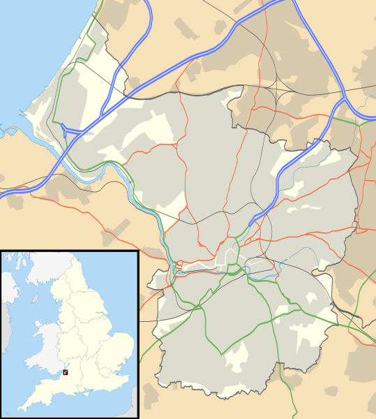
Map of Bristol, UK with the following information shown:
Equirectangular map projection on WGS 84 datum, with N/S stretched 160% Geographic limits:
|
| Date | |
| Source |
|
| Author | Nilfanion, created using Ordnance Survey data |
| Permission (Reusing this file) |
This file is licensed under the Creative Commons Attribution-Share Alike 3.0 Unported license. Attribution: Contains Ordnance Survey data © Crown copyright and database right
|
| Other versions | File:Bristol UK district map (blank).svg - Blank map |
.svg)
File history
Click on a date/time to view the file as it appeared at that time.
| Date/Time | Thumbnail | Dimensions | User | Comment | |
|---|---|---|---|---|---|
| current | 17:58, 26 September 2010 | | 1,138 × 1,266 (683 KB) | Nilfanion | {{Information |Description=Map of Bristol, UK with the following information shown: *Administrative borders *Coastline, lakes and rivers *Roads and railways *Urban areas Equirectangular map projection on WGS 84 datum, with N/S stretched 160 |
File usage
More than 100 pages use this file. The following list shows the first 100 pages that use this file only. A full list is available.
- Arnolfini, Bristol
- Arnos Vale Cemetery
- Ashton Vale
- Avon Gorge
- Avonmouth
- Avonmouth Bridge
- Badminton School
- Barton Hill, Bristol
- Black Castle, Bristol
- Blaise Castle Estate
- Blaise Hamlet
- Bower Ashton
- Brandon Hill, Bristol
- Brentry
- Brislington
- Bristol Cathedral
- Bristol Central Library
- Bristol City W.F.C.
- Bristol Crown Court
- Bristol Industrial Museum
- Bristol Museum & Art Gallery
- Bristol Old Vic Theatre School
- Bristol Royal Infirmary
- British Empire and Commonwealth Museum
- Cabot Tower, Bristol
- Catbrain
- Church of St John the Baptist, Bristol
- Clifton Cathedral
- Clifton Down
- Clifton Suspension Bridge
- Colstons Almshouses
- Coombe Dingle, Bristol
- Crew's Hole, Bristol
- Durdham Down
- Eastville Stadium
- Fishponds
- Former Bank of England, Bristol
- Georgian House, Bristol
- Glenside, Bristol
- Glenside Museum
- Golden Hill, Bristol
- Great Gatehouse, Bristol
- Holy Trinity Church, Westbury on Trym
- Horseshoe Bend, Shirehampton
- Hotwells
- Jacob's Well, Bristol
- King Street, Bristol
- King William Ale House
- Kings Weston House
- Kingsdown, Bristol
- Knowle West
- Lawrence Weston, Bristol
- Llandoger Trow
- Manor Hall, Bristol
- Mayfield Park, Bristol
- Merchant Venturers Almshouses
- Old Post Office, Bristol
- Pen Park Hole
- Portland Square, Bristol
- Purdown BT Tower
- Quakers Friars
- Red Lodge Museum, Bristol
- Redcliffe, Bristol
- Redfield, Bristol
- Redland Chapel
- Royal Fort House
- Royal West of England Academy
- Sea Mills, Bristol
- Shirehampton
- Sneyd Park
- Snuff Mills
- Southmead Hospital
- Speedwell, Bristol
- Spike Island, Bristol
- St Brendan's Sixth Form College
- St Mary Redcliffe
- St Matthias, Bristol
- St Nicholas' Almshouses
- St Paul's Church, Bristol
- St Pauls, Bristol
- St Philip's Marsh
- St Stephen's Church, Bristol
- St Werburghs
- Stapleton, Bristol
- Temple Church, Bristol
- The Chessels
- The Downs, Bristol
- The Exchange, Bristol
- The Old Duke
- The Thekla
- Tobacco Factory
- Totterdown
- Victoria Rooms, Bristol
- Watershed, Bristol
- We the Curious
- Westbury College Gatehouse
- Westbury Park, Bristol
- Whitehall, Bristol
- Wickham Theatre
- Wills Hall
View more links to this file.
Global file usage
The following other wikis use this file:
- Usage on ar.wikipedia.org
- Usage on bn.wikipedia.org
- Usage on ceb.wikipedia.org
- Usage on el.wikipedia.org
- Usage on es.wikipedia.org
- Usage on fa.wikipedia.org
- Usage on fr.wikipedia.org
- Usage on it.wikipedia.org
- Usage on ja.wikipedia.org
- Usage on kn.wikipedia.org
- Usage on ml.wikipedia.org
- Usage on os.wikipedia.org
- Usage on pl.wikipedia.org
- Clifton Suspension Bridge
- Ashton Gate
- Memorial Stadium
- Uniwersytet Bristolski
- Bristol Temple Meads
- Avonmouth
- Shirehampton
- Bedminster (przystanek kolejowy)
- Bristol Zoo
- Katedra św. Piotra i św. Pawła w Clifton
- Parson Street
- Lawrence Hill (stacja kolejowa)
- Stapleton Road
- Montpelier (stacja kolejowa)
- Redland (stacja kolejowa)
- Clifton Down
- Sea Mills (stacja kolejowa)
- Shirehampton (stacja kolejowa)
- Avonmouth (stacja kolejowa)
- St Andrews Road
- Stockwood (Bristol)
- Wieża Cabota
- Katedra w Bristolu
- Bedminster (Bristol)
- Knowle (Bristol)
View more global usage of this file.