No higher resolution available.
Brighouse_High_School,_Sixth_Form_College_-_geograph.org.uk_-_150719.jpg (640 × 480 pixels, file size: 134 KB, MIME type: image/jpeg)
| This is a file from the Wikimedia Commons. Information from its description page there is shown below. Commons is a freely licensed media file repository. You can help. |
Summary
| Description |
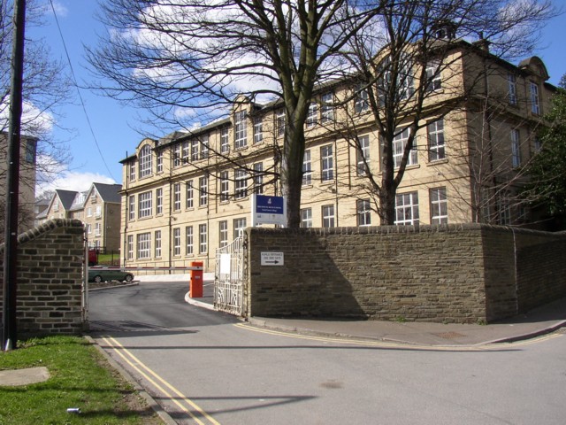
English: Brighouse High School, Sixth Form College Brighouse Grammar School Sixth Form Centre, Parsonage Lane. The building was initially for the Brighouse & District Girls' Secondary School, and was designed by Sutcliffe & Sutcliffe and work started in June 1909. It opened on 6 September 1910. The Brighouse & District Technical School was opened in the same building in September 1910, having been moved from the Mechanics' Institute. There were additional premises for engineering and other subjects.
Following the Education Act (1944), it became the Brighouse Girls' Grammar School. In 1984 there was a major upheaval of Calderdale schools, and the Girls' Grammar school merged with Brighouse High School. There was a transfer of pupils year by year and eventually the building became the High School Sixth Form College. Sources: R Mitchell Brighouse: The birth and death of a borough 1976, Malcolm Bull's Calderdale Companion website. |
| Date | |
| Source | From geograph.org.uk |
| Author | Humphrey Bolton |
| Attribution (required by the license) | Humphrey Bolton / Brighouse High School, Sixth Form College / |
| Camera location | | View this and other nearby images on: OpenStreetMap |
|---|
_heading:315.00&language=en)
| Object location | | View this and other nearby images on: OpenStreetMap |
|---|
_heading:315.00&language=en)
Licensing

|
This image was taken from the Geograph project collection. See this photograph's page on the Geograph website for the photographer's contact details. The copyright on this image is owned by Humphrey Bolton and is licensed for reuse under the Creative Commons Attribution-ShareAlike 2.0 license.
|
This file is licensed under the Creative Commons Attribution-Share Alike 2.0 Generic license.
Attribution: Humphrey Bolton
- You are free:
- to share – to copy, distribute and transmit the work
- to remix – to adapt the work
- Under the following conditions:
- attribution – You must give appropriate credit, provide a link to the license, and indicate if changes were made. You may do so in any reasonable manner, but not in any way that suggests the licensor endorses you or your use.
- share alike – If you remix, transform, or build upon the material, you must distribute your contributions under the same or compatible license as the original.
File history
Click on a date/time to view the file as it appeared at that time.
| Date/Time | Thumbnail | Dimensions | User | Comment | |
|---|---|---|---|---|---|
| current | 06:41, 31 January 2010 | | 640 × 480 (134 KB) | GeographBot | == {{int:filedesc}} == {{Information |description={{en|1=Brighouse High School, Sixth Form College Brighouse Grammar School Sixth Form Centre, Parsonage Lane. The building was initially for the Brighouse & District Girls' Secondary School, and was designe |
File usage
The following pages on the English Wikipedia use this file (pages on other projects are not listed):
Global file usage
The following other wikis use this file:
- Usage on www.wikidata.org