No higher resolution available.
Bethesda,_Burry_Green_-_geograph.org.uk_-_1313145.jpg (640 × 480 pixels, file size: 83 KB, MIME type: image/jpeg)
| This is a file from the Wikimedia Commons. Information from its description page there is shown below. Commons is a freely licensed media file repository. You can help. |
Summary
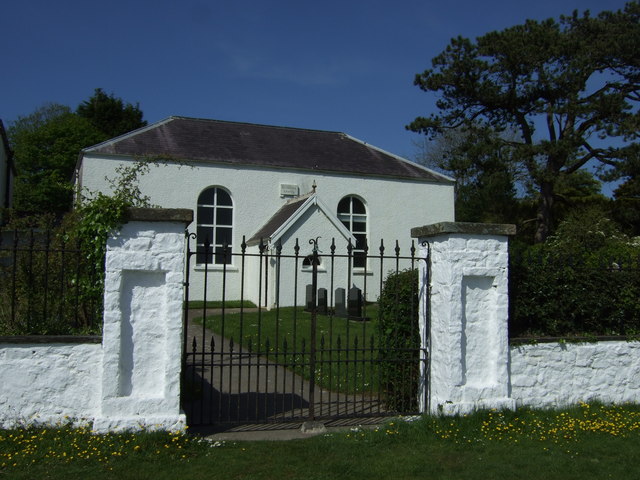
| Description |
English: Bethesda, Burry Green Bethesda Chapel was built in 1813 or 1814 by Diana, Baroness Barham (d. 1823), who also built and established other chapels and schools in the area. During the first years, the Chapel was supplied by ministers of the Countess of Huntingdon's Connexion, staying for about two months at a time. The Rev. William Griffiths, the 'father' of Calvinistic Methodism in Gower, was appointed minister of the Chapel in 1824 under the patronage of Lord Barham, and remained there until his death.
The Rev. William Griffiths (1788-1861) was a Calvinistic Methodist minister, born at Clydau, Pembrokeshire. In 1807 he was forced to enlist in the militia and was influenced by the Methodists whom he later joined. In 1817, at the request of Lady Barham, he was sent as a missionary to the English-speaking community of Gower where he founded several churches. He is known as the 'Apostle of Gower'. |
| Date | |
| Source | From geograph.org.uk |
| Author | ceridwen |
| Attribution (required by the license) | ceridwen / Bethesda, Burry Green / |
| Camera location | | View this and other nearby images on: OpenStreetMap |
|---|
_heading:45.00&language=en)
| Object location | | View this and other nearby images on: OpenStreetMap |
|---|
_heading:45.00&language=en)
Licensing

|
This image was taken from the Geograph project collection. See this photograph's page on the Geograph website for the photographer's contact details. The copyright on this image is owned by ceridwen and is licensed for reuse under the Creative Commons Attribution-ShareAlike 2.0 license.
|
This file is licensed under the Creative Commons Attribution-Share Alike 2.0 Generic license.
Attribution: ceridwen
- You are free:
- to share – to copy, distribute and transmit the work
- to remix – to adapt the work
- Under the following conditions:
- attribution – You must give appropriate credit, provide a link to the license, and indicate if changes were made. You may do so in any reasonable manner, but not in any way that suggests the licensor endorses you or your use.
- share alike – If you remix, transform, or build upon the material, you must distribute your contributions under the same or compatible license as the original.
File history
Click on a date/time to view the file as it appeared at that time.
| Date/Time | Thumbnail | Dimensions | User | Comment | |
|---|---|---|---|---|---|
| current | 16:07, 27 February 2011 | | 640 × 480 (83 KB) | GeographBot | == {{int:filedesc}} == {{Information |description={{en|1=Bethesda, Burry Green Bethesda Chapel was built in 1813 or 1814 by Diana, Baroness Barham (d. 1823), who also built and established other chapels and schools in the area. During the first years, the |
File usage
The following pages on the English Wikipedia use this file (pages on other projects are not listed):
Global file usage
The following other wikis use this file:
- Usage on fr.wikipedia.org